You know what would be fun this Memorial Day weekend? Take a long trip on a really long greenway.
The Neuse River Trail.
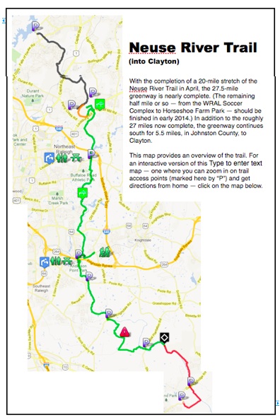
The Neuse River Trail is the backbone of Raleigh’s rapidly growing greenway system. Last fall, the first 6.5 miles of the eventual 27.5-mile greenway opened, running from the northern trailhead near the base of Falls Lake dam downstream to the WRAL Soccer Park off Perry Road. In April, another 20 miles opened, from Horseshoe Farm Park off U.S. 401 downstream to the Johnston County Line. And you needn’t stop there: Another 5.5 miles of paved, 10-foot greenway continues to Clayton.
About a mile of greenway remains, and that should open in early 2014.
The latest 20 miles to open is worthy of your immediate attention. The trail crosses the Neuse seven times, twice on simple, graceful suspension bridges. There is only one true brush with development (for just a few hundred yards north of Anderson Point Park); otherwise, the trail does a remarkable job of using the Neuse’s thin riparian border to shield you from the city just beyond. The trail has only one road crossing of any note (the rural, two-lane Brownfield Road near the south end), allowing for miles — and miles and miles — of uninterrupted travel.
For the most part, the Neuse River Trail follows its namesake river. There’s a 3.5-mile stretch near the southern end where it departs the river and takes in rolling, white-fenced pasture. The trail takes you through wetlands with a primordial feel, it passes, at the right release from Falls Lake dam, Class II whitewater (above Anderson Point). There are water and restroom breaks (at Buffaloe Road Athletic Park and Anderson Point Park), there are plaques along the way to let you in on the Neuse’s human and natural history.
For an interactive version of this map, click on it.
View Neuse River Trail: Horeseshoe Farm to Johnston County in a larger map
Already, the trail is exhibiting its broad appeal. Cyclists looking to get some miles in appreciate the traffic-free aspect of the trail (especially near the southern end). Likewise, distance runners like the long stretches and the option to run on the trail’s more joint-friendly crushed gravel shoulders. The hardwood canopy along much of the trail provides relief from all but the mid-day sun, making it ideal for long strolls. Families bring their kids here, in strollers for the youngest, with training wheels for those exploring their independence.
We’re here to help you plan this adventurous aspect to your Memorial Day weekend. First, with a slideshow to whet your interest, then, with two maps to help you plan your trip. The top map is an overview of the entire trail, including the 5.5-mile stretch that continues into Johnston County, to Clayton. (Did we forget to mention that the greenway is actually 32 miles?) The second map is interactive: click on it and you can drill in on exact trailhead locations, get directions from your home, and get a better sense of what’s where.
Over the next couple weeks we’ll provide more detailed maps of the trail broken down by section. For now, these should suffice.
Happy exploring!
* * *
Like us on Facebook and get health, fitness and outdoors news throughout the day.


Joe, that trail looks excellent. I’m wondering what the best way to connect the Crabtree Trail up w/ the Falls Lake trail by bike is. It would appear that there is a stretch yet to be finished on the Crabtree Trail from New Bern to the Falls Lake Trail. Any ideas?
I’m sorry, I meant the Walnut Creek trail, not the Crabtree trail.
Having not attempt that connection myself I’m reluctant to make a suggestion: It’s one thing to drive a stretch, another completely to bike it. But perhaps there’s someone out there who has and can make a recommendation?
This news story ran on WRAL on June 1st, 2013-
http://www.wral.com/lifestyles/travel/video/12504500/#/vid12504500
Here is base map for trails-
http://goo.gl/maps/D3k62
Cheers,
Tim