 At our weekly GetHiking! Triangle hike a couple weeks back, I was approached at the trailhead by a woman who introduced herself as being from Virginia Beach, Va. She, her daughter and a friend were in town asked if they might tag along with our group.
Of course, I said. “So you’re in town for the weekend?,” I asked, being the sociable — and a little nosy — hike leader. “What else are you doing?”
“No,” she replied. “We just drove down to hike. We’re driving back afterward.”
Eight hours of driving to hike at Umstead State Park? Now, I love Umstead: I hike, run or bike there two or three times a week. But it’s 10 minutes from my house. Would I put in eight hours behind the wheel for a day trip?
Why Umstead? I asked.
“It was the closest place I could find,” she replied.
For future reference, I rattled off several alternatives much closer to her home:
- Merchants Millpond State Park, 9 miles of hiking trail just 1 hour 15 minutes from Virginia Beach.
- Medoc Mountain State Park, 10 miles of trail, 2 hours 20 minutes.
- Goose Creek State Park: 8 miles, 2 hours, 30 minutes.
- Nags Head Woods Ecological Preserve: 5 miles, 1 hour, 40 minutes
- Alligator River and Pocosin Lakes National Wildlife Refuges, both with miles of gravel roads, both within a couple hours.
She was surprised. None of those options turned up in her Google search.

I shared this story last Wednesday with members of the Northeast Commission, one of seven statewide regional economic development organizations created in the 1990s by the General Assembly (and defunded as of June 30 this year by the same). The Northeast Commission represents 16 counties in the northeast corner of the state, and one of their focus areas has been figuring out how to boost ecotourism in the region. Hence, the preponderance of shaking heads at the table.
Getting the message out about northeast North Carolina’s adventure potential has been an ongoing challenge.
The woman from Virginia Beach should have quickly learned of the hiking options in her own North Carolina backyard. She should also have learned that there was no better time to hike a coastal swamp or forest than on a day when the daytime high wouldn’t get much above 60, remaining just cool enough to keep the local pest population from activating.
And hiking isn’t even what the region is known for. Or should be known for.
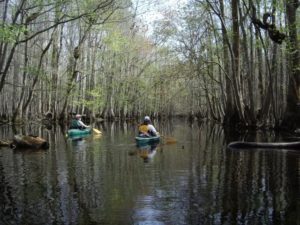
It’s a paddling paradise.
Paddling intimate blackwater creeks; paddling lazy rivers, paddling mysterious swamps, paddling marshes, sounds, the ocean. Some of the best flat-water paddling in the country, and it remains a well-kept secret, much to the Northeast Commission’s dismay.
There are hundreds of miles of designated paddle trails in the northeast region. For years, access was pretty much by word-of-mouth; only the locals knew which underpass made for a good put-in, which little-known boat ramp a decent take-out. Then, in the 1990s came the North Carolina Coastal Plain Paddle Trails guide, which identified access points on more than 2,500 miles of waterways in the coastal plain. Helpful, but it doesn’t offer a sense of what each section is like. You get more of that in Paul Ferguson’s “Paddle Trails of Eastern North Carolina.” But as I told the NEC, in order to lure folks you need to give them a good sense of what they’re driving from, say, Philadelphia — or even Raleigh — for.
There are some sparks of that.
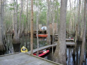
- Roanoke River. It doesn’t take but 30 seconds on the Roanoke River Partners website before you’re ready to reserve one (or several) of the 16 camping platforms on the river. For each platform there are photos, details about the campsite and an enticing description. You can reserve a site immediate, online.
- Pamlico County Paddle Trails. This site includes the necessary details and esthetic insights helpful in planning a trip. Waterways coverd are the Bay River, Goose Creek, Bay River to Oriental, Oriental, Oriental to Upper Broad Creek.
- Albemarle Regional Paddle Trails. This site acts as a clearinghouse for more localized maps in the Albemarle region.
That’s a start to help you plan a paddle trip to the northeast part of the state.
Another way to learn the area? Attend an event, where you’ll be guided and have the opportunity to rub shoulders with local paddlers, who may, if you seem like a decent sort, share a local favorite trip or two.

Two upcoming events we know of:
- Roanoke River Paddle Days, Sunday, April 6, 7:30 a.m. Coffee and “breakfast snacks” start the day, followed by a 12-mile paddle from Jamesville to Plymouth. There’s a rest stop at the Bear Run Camping Platform (so you can check and see what that’s about), followed by lunch back in Jamesville, at the Cypress Grill. Cost is $35, with proceeds benefitting the Roanoke River Partners. A great introduction to the Roanoke.
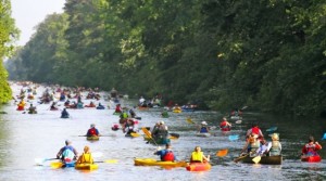
- Paddle for the Border, Saturday, May 3, 8 a.m., Dismal Swamp Canal. You know those promotions where someone dumps about 400 little rubber ducks into a river for comic effect? That’s the image that comes to mind with Paddle for the Border, an annual occurrence where 375 canoes and kayaks paddle the 7.5 miles from North Carolina’s Dismal Swamp State Park in South Mills north to Chesapeake, Va. $40 fee includes shuttle, breakfast and lunch. Adding to the paddle’s allure is the Great Dismal’s colorful past. If you sign up, plan to read Bland Simpson’s “The Great Dismal: A Carolinian’s Swamp Memoir”beforehand.
This is the tip of the iceberg, but it’s a start. We’ll work to explore beneath the northeast’s surface in the months ahead.