The hike at Fort Fisher State Park Saturday is only a mile and a half, but it’s a well-appointed mile-and-a-half; there’s a rare introduction to the misunderstood pursuit of trail running along the Eno River Saturday afternoon; and on both Saturday and Sunday, those crazy videos of skateboarders bombing down twisty mountain roads comes to life at Mount Jefferson.
Tag Archives: Mountains-to-Sea Trail
Spring along the Eno
Saturday, our GetHiking! group enjoyed spring full throttle on a 5-mile hike of the Mountains-to-Sea Trail in Durham, from Penny’s Bend up the Eno River to West Point on the Eno city park.
Content from Spring along the Eno
The hike was full of the typical hiker bonhomie: catching up with hikers who had hibernated over the winter, learning the stories of new hikers, comparing snacks. It also offered an eyeful of the spring wildflower display that the Eno River valley is known for. After a winter-delayed harvest, the trail was ablaze in spring color: mayapple, fiddlehead fern, toothwort, green-and-gold, speedwell, rue-anemone, Dutchaman’s breeches, spring beauties, periwinkle, American speedwell and more.
Click on the links to learn more about each wildflower. A great local guide we’ve found is A Virtual Wildflower Garden Across Time, which categorizes wildflowers by color and typical date of appearance.
This weekend: Learn a thing

Learn your shorebirds at the coast, learn your wildflowers in the mountains. Meanwhile, in the Piedmont you can learn a new stretch of trail.
Coast
Friday morning, our friends at the North Carolina Coastal Federation, along with Wrightsville Beach Scenic Tours, are conducting a Coastal Birding Cruise. The one-hour boat ride, aboard The Shamrock, will explore the marsh and backwaters around Wrightsville Beach searching for shorebirds, from the pelican and black skimmer to (hopefully) the endangered piping plover (pictured). Guides will explain the area’s ecology as well. A great way to learn more about an area you may visit frequently, but likely don’t know well.
Spring, show me a sign

I’ll remember my three hikes over the weekend as such: long stretches of brown interrupted by flashes of the wrong kind of green, the less frequent wrong patches of white and one inspiring — but again, wrong — flash of yellow.
My objective on the trail this past weekend? Find signs of spring.
Ambitious, considering snow, ice and cold had dominated late winter until early last week. Then one 75 degree day, another in the 60s and — consarn it! — where’s spring? According to Carrboro naturalist Dave Cook and his “The Piedmont Almanac,” as early as the third week of February, “the first trout lilies and spring beauties might adventurously bloom” on slopes with southern exposures. By this, the second week of March, Cook writes, we should expect to see trout lilies in their “full glory.” Cook offers a caveat: your results may vary depending upon the weather.
Since second grade, I’ve avidly watched for the first signs of spring, though the cues have changed over the years. Beginning in early February I would rush home after school to rip open the sports section of The Denver Post, then an afternoon paper, and look for the first box score of spring training. Just seeing the early at-bats of Harmon Killebrew and Moose Skowran made me feel 10
The MST: A completed path or a work in progress?
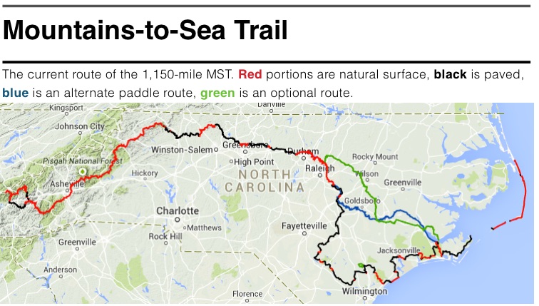
I have a small disagreement with the Friends of the Mountains-to-Sea Trail. They claim that the statewide footpath linking Clingman’s Dome on the Tennessee line with Jockey’s Ridge on the Atlantic is complete. I believe that because two-thirds of the trail is on paved roads, that it is not.
“One of the problems we encounter is the perception that the trail is not complete,” Kate Dixon, executive director of the Friends of the Mountains-to-Sea Trail told the Friends at it’s annual meeting Saturday at Elon University.
While Kate and the Friends are pushing hard to convert the trail from asphalt to dirt — 150 miles have been converted since 2008 — she contends the trail is indeed complete, currently running about 1,150 miles across the state. The Friends are even feverishly producing a series of guidebooks detailing the trail, regardless of its composition.
Here’s where I’m coming from: As someone who writes about places to explore, I cannot, in good conscience, suggest that people hike a paved road. In my experience, that’s not the escape most people are looking for. Besides, considering that 620 miles of the MST are on bonafide footpath, why suggest that someone hike even a mile on a paved road with little or no shoulder when they could be hiking some of the best trail in the state? The 300 continuous miles of stunningness from Waterrock Knob to Stone Mountain, for instance.
But I like to keep an open mind on the matter, which is why at Saturday’s annual meeting I attended a panel discussion involving the 10 hikers who hiked the entire MST in 2014. (To date, 47 hikers have completed the MST.) They’d hiked (in one case, biked) about 400 miles on road: how did they find the experience?
In part, it was what you might expect.
“The monotony of the road killed my feet,” said Patrick le Beau. The asphalt, the continuous pounding.
Dogs were also an issue.
“My first day on the road I encountered eight to 10 dogs,” said le Beau. “I averaged about one dog encounter a day.”
And there was the traffic.
“You haven’t lived until you’ve had 10 pig trucks pass you along the road,” said Craig “Jet Lag” Smith.
And yet …
One of the reasons for a statewide trail is to get to know the state’s abundant and diverse natural beauty. Another reason: to get to know its people.
“You don’t realize how great walking on roads is until you meet the people who will give everything to you,” said Ben Banick, who completed the trail with Hannah Krureger. Both are students at Appalachian State University.
“People will buy you lunch, they’ll give you a ride,” added Sharon “Mama Goose” Smith, an Iraq war veteran who hiked on behalf of the Warrior Hike program.
“It restores your faith in humanity,”
People, the hikers agreed, are a large part of what makes hiking the MST special. And you tend not to see as many people hiking a remote stretch in the Linville Gorge Wilderness and you do hiking a two-lane in eastern North Carolina.
“It’s not so much about hiking,” added Jet Lag, “but about people who are curious about what you’re doing walking down their street with a backpack.”
Guidebook writer and hike leader Danny Bernstein moderated the discussion. Bernstein wrote about her completion of the MST in her 2011 book, “The Mountains-to-Sea Trail Across North Carolina,” and she’s a vocal advocate of the road portions of the trail. In large part, that’s because of the people you meet. But she also has a more practical reason for embracing the road sections.
“None of us in this room will be around when the trail is finished,” she told the audience. “So we might as well hike it.”