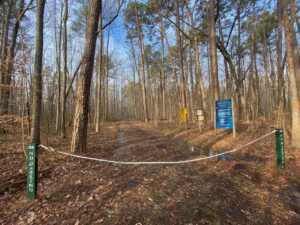
Gate 35 appeared almost as a dream.
I was driving north from Chapel Hill to Hillsborough on Old NC 86 late one afternoon in early December, a time of fading light known as the gloaming. The sun hadn’t officially set, but with a mostly cloudy sky it might as well have. Little light remained, but just enough that, passing by at 55 miles per hour, I thought I glimpsed what appeared to be dirt road guarded by a familiar gate, a chalk-white chain-link iron bar suspended between two forest green posts. I made a mental note of the location, and a Post-It Note to return and check it out.
And I did, this morning. I slowed as I neared the suspected sighting site and still drove past the recessed opening. I hit the brakes, backed up and sure enough, there it was, Gate 35.
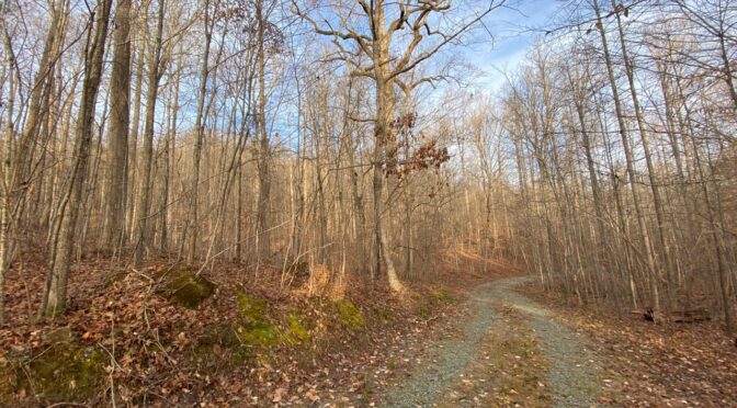
I’d checked the Duke Forest map before heading out and learned there was about a mile of trail (in the form of a gravel access road closed to traffic) that wrapped around the southern flank of Bald Mountain. From the road, the terrain appeared pancake flat. But the topo map showed 751-foot Bald Mountain rising more than 100 feet above the surrounding countryside. For the Piedmont, that’s an impressive hump.
The trail, only a mile long, did not disappoint. That flat terrain visible from the road made for a nice 5-minute warm-up. Then the trail turned south, traversing the mountain’s eastern flank, then southern flank. Bald Mountain’s prominence was cloaked by the preponderance of saplings battling for survival in this emerging hardwood forest. But upon reaching the mountain’s western exposure, the clutter abetted and a long northeast-trending ridge to the summit appeared crisp against the early morning blue sky. A summit bid would be possible. But not today.
Today, I was content to stay on the trail and follow it to its end. As is the case with many one-way paths in Duke Forest, not a unified woodland but several tracts comprising more than 7,000 acres spread over three counties, this one ended in a small cul-de-sac before a dense wall of young pine saplings. In fact, the forest all around had again filled in with the suffocating density of succession. Nice spot, I thought. Next time, remember to bring a camp chair — better yet, a hammock — a thermos of coffee, and a book.
This trail, this hidden gem, had eluded me over years of travel up and down Old NC 86. Then, for whatever reason, a quick glance out of a speeding (not “speeding,” really; I was going the speed limit) and bam! — a new trail to add to my local repertoire. A most pleasant, if not long, hike. And one, because of its secluded nature, one I may ever see anyone else on.
* * *
I mention Gate 35 for two reasons. One, if you’re planning a Christmas Day hike and live in North Carolina, you’ll need to hike somewhere other than a North Carolina State Park: it’s the one day of the year when the gates don’t open. Thus, you’ll need to find an alternative. An alternative such as your own Gate 35.
Being on the lookout for Gate 35s will continue to behoove you long past Christmas Day. Trails have become more crowded with the pandemic, and while some of those new hikers will disappear as vaccinations increase and the pandemic abates, many of them won’t. The solitude we’ve long sought on the trail will be harder to find, unless you find our own Gate 35s. Here are some tips for making that happen, taken from our “Explore Your Neighborhood: A Guide to Discovering the World Immediately Around You,” published in April.
First, fire up Google Maps. Then:
- Begin with a distance you’re comfortable traveling, both walking from your front door and within a short drive (my comfort zone, again, is 10 miles). To determine distances, call up Google Maps, then, in the menu bar, click on “Your Places.” Click on “Maps,” then “Create Map.” You’ll get a map of the U.S.: keep double clicking on “North Carolina” until you get down to your neighborhood. Then use the distance tool — ruler icon — to determine crow-fly distances from where you live.
- Look for splotches of green. They may be golf courses or cemeteries, or they may be parks. Keep in mind that while some parks are closed, many have closed only rec centers, restrooms, playgrounds and other physical facilities;:their trails and open fields may still be open.
- Look for green-dashed lines. Green dashed lines indicate a natural surface hiking trail.
- Look for solid green lines. These often indicate a paved walking trail.
- Look for green pins with trees in them. Some parks are marked with these.
- Look for streams and creeks. Greenways and trails sometimes parallel waterways. Even if there aren’t actual trails, you may find fishing paths or game trails that offer access. Even if these paths don’t go far, they make for a nice diversion into the natural world.
With a little scouting and the right attitude, you can find an adventure you didn’t know was there.
* * *
For more guidance on trail finding
Our 44-page “Explore Your Neighborhood: A Guide to Discovering the World Around You,” includes a variety of tips to help you ferret out the trails less traveled, the adventures less appreciated. Hidden gems that go unappreciated not because they aren’t worthy, but because they’re just a little more challenging to find. Available in paperback and Kindle. Learn more about “Explore Your Neighborhood” here.