We weren’t quite 4 miles into the hike, not far past Camp 5 and beginning a long downhill stretch when the realization struck: the 30 or so hikers with me, most of whom had never hiked hiked more than 5 miles, were under the impression that the hike was a little more than half over. That we had about 3 miles to go, tops, and when those 3 miles were over they’d be back at the trailhead, basking in their new PRs, motoring to a local brewpub for a celebratory pint.
There was a peppiness about them, a lightness fueled by the realization that having gone this far and only having 3 miles to go, they were going to finish. They knew what 3 miles felt like, they knew they had it in ‘em.
What they didn’t know was another 7 miles felt like, and 7 miles, I just realized, was the actual distance we had left. Their leader had advertised a 7.2-mile hike, but their leader had made a slight miscalculation.
* * *
I started leading hikes a dozen years ago, first as part of a fundraising effort, later as a way to simply get new people on the trail. After years of writing about ways for newbies to get out and explore, now, I was going to take them myself. In August of 2013 we held an introductory meeting for the new GetHiking! program at the Great Outdoor Provision Co. store in Raleigh; that gathering drew nearly 90 people. The following Saturday we held our first hike, on the Company Mill Trail at Umstead State Park. Fifty-five people signed up.
Part of the program’s appeal was that we catered to beginners: start hiking with us now and come November we’ll have you ready to do complete a 7-mile hike.
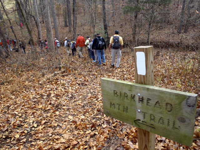
That fall we hiked every other weekend, we did midweek, after-work hikes in the early fall that turned into night hikes come November. We hiked the Mountains-to-Sea Trail, along the Eno River, at Hanging Rock, at Harris Lake. By mid-November, the hikers were ready for their test in the Uwharries. Forty-six hikers signed up to hike the Birkhead Wilderness of the Uwharrie National Forest west of Asheboro on Nov. 16, a hike advertised as 7.2 miles long.
The route was one I had done numerous times. It was Hike No. 36 in my 2007 guidebook, “100 Classic Hikes in North Carolina,” which came out in 2007, it was Trip No. 35 in my “Backpacking North Carolina” guidebook that came out four years later. I’d hiked the route at least twice with a GPS, the distance coming out at a little more than 7 miles both times. It was, I knew, a 7-mile hike — if you started from the Robbins Branch trailhead.
About a week before the hike I was driving back from Charlotte on N.C. 49 when I remembered hearing about a new trailhead opening on the north end of the Birkhead Mountain Trail, off Tot Hill Road. If that was true, it would shave a good 20 minutes off the drive for hikers coming from the Triangle: Tot Hill was just west of Asheboro off 49 — on paved road. Getting to Robbins Branch was trickier, requiring a counterintuitive turn off 49, finding a dusty two-lane called Lassiter Mill, then keeping an eye peeled for the gravel road that quietly came in from the left and lead, over rocky terrain, to the Robbins Branch Trailhead. If the Tot Hill Trailhead and parking were open, that would make the hike so much easier to get to. So I watched for Tot Hill Road, turned, and in less than 2 miles came to a gleaming new trailhead complete with gravel parking lot. It was a good find. It would have been better if I’d parked and taken a minute to hike even a short distance down the trail.
* * *
The beauty of the Robbins Branch Trailhead was that once you finally found it, it was right on the Birkhead Wilderness Loop. Park, pick up either Hannah’s Creek Trail headed east, or Robbins Branch Trail headed north. Both connected to the Birkhead Mountain Trail to complete the 7.2-mile loop.
When hike day arrived, we gathered in the new Tot Hill lot, discussed the hike, then started hiking south on the Birkhead Mountain Trail. I quickly became engaged in conversation, the time and scenery passed. How much time I wasn’t quite sure when we reached the junction with Robbins Branch, though it did seem like we’ve been hiking for a while. In fact, we’d been on the trail for a good 45 minutes — or 2 miles — and we were just now getting to the route.
But it was a gorgeous fall day and the distraction of crystal blue skies, waning fall color and the bonhomie of my new hiking friends distracted me from facing the truth. It wasn’t until around Mile 4, just past Camp 5, that I began to emerge from full denial; it was another 15 minutes, now on the Hannah’s Creek Trail, that I was forced to come clean.
“Hey, my watch says we’re at mile 7 — we must be near the end,” someone behind me announced. Several hikers whooped in response.
“Well, here’s a funny thing,” I began, then proceeded to explain that I’d failed to take into account the two miles of trail just to get to the actual route.
“So … that means in addition to the extra 2-mile hike in, we have another extra 2 miles headed out?”
“That’s 11 miles,” someone else chimed in.
“More than 11 miles,” added added a third, the “more” delivered in an ominous tone.
* * *
Revenge, as the French saying goes, is a dish best served cold.
A couple weeks later we were hiking the New Hope Overlook trails at Jordan Lake, a surprisingly hilly 5.4-mile route. We were on the Blue portion of the hike, trudging up a long climb when someone asked, “How much farther?”
“Maybe a mile and a half,” I said.
“Is that in real miles,” asked one of the hikers from the Birkhead hike, “or ‘Joe miles’?”
“Ha ha!” I said. OK, fair enough.
But two weeks later at White Pines, my mileage estimate drew the same response: “Are those actual miles … or Joe miles?” And again the following week at Little River Regional Park, the week after that on the Mountains-to-Sea Trail … . More than 7 years later, 7 years after that one slight miscalculation, I still get that response: Are those real miles? Or Joe miles?
For the longest time, I tried to keep close track of where we were on the trail and not give an answer unless I knew exactly where we were and how much farther we had to go. Made no difference: the more I tried to defend my estimate, then more Joe miles I got in return. Now when they ask?
I turn, give a sly grin and answer, “Joe miles, of course.”
* * *
GetHiking! Southeast Podcast: the Uwharries
Intrigued by today’s mention of the Uwharrie Mountains in the Uwharrie National Forest west and south of Asheboro? On this week’s GetHiking! Southeast Podcast we talk with Don Childrey, author of the “Uwharrie Lakes Region Trail Guide.” First published in 1996, it was updated in 2014 and today includes 113 named trails covering more than 215 miles of trail. Better still, it includes 95 multi-day trips. Listen to our conservation with Don here.
GetHiking! Guide to Exploring the Birkhead Wilderness
Check out our 7-page guide to exploring the Birkhead Wilderness, including some off-trail adventure, here.