When I lead a hike, I like to know a little about the land we’ll be hiking. About the natural history, certainly. Sometimes, especially for a trail I haven’t done in a while or during a particular season, I’ll scout the trail with my PictureThis app, which does a remarkable job of IDing plants, and providing their story.
I also like to know a bit about the land’s human history, about who lived on the land, how they got there, how they prospered — or managed to eke out a living. I’m especially interested in the stories of the first people to inhabit the land.
Look carefully and the land itself will reveal some of the human story. Some trails piggyback on old roadbeds that were the highways of a century or two ago, the paths people used to get to town, or the nearest mill. Those trails often pass old stone foundations, or rock chimneys, or depressions that were once root cellars, the refrigerators of the pre-refrigeration era. Sometimes you find rock piles seemingly in the middle of nowhere, the result of efforts, often by children, to prepare land for farming. Rows of deep furrows in the ground suggest a cash crop of tobacco.
The best place to start looking for such signs of the past? Near stately white oaks, which were left by early settlers as windbreaks and protection from the weather.
Human history: Post European invasion
Delving deeper into this more recent history may constitute a visit to the land manager’s website. Each of the 41 North Carolina State Parks, for instance has a History link on its home page. Some go back farther than others. The “History Highlights” section for Umstead State Park in Raleigh, for instance, begins: “Long before the first settlers, the area now known as William B. Umstead State Park was an untamed land. American bison, elk, bobcats and wolves roamed majestic forests of oak, hickory and beech.” There’s brief mention of Native Americans and of the first European settlers, and more about how the park came to be a park.
If you’re fortunate, a favorite trail network may adjoin a historic site. The Triangle Land Conservancy’s Horton Grove Nature Preserve in Bahama, north of Durham, adjoins Historic Stagville, where you can learn about the massive 30,000-acre Bennehan-Cameron plantation that once enslaved about 900 people. Horton Grove was once part of the plantation, and you can hike past the original slave quarters, a huge barn and the plantation house. With this knowledge, it can be eerie to hike Horton Grove’s peaceful woods and know it’s past.
But if you want to go back much farther, before the arrival of the first Europeans, information is hard to find.
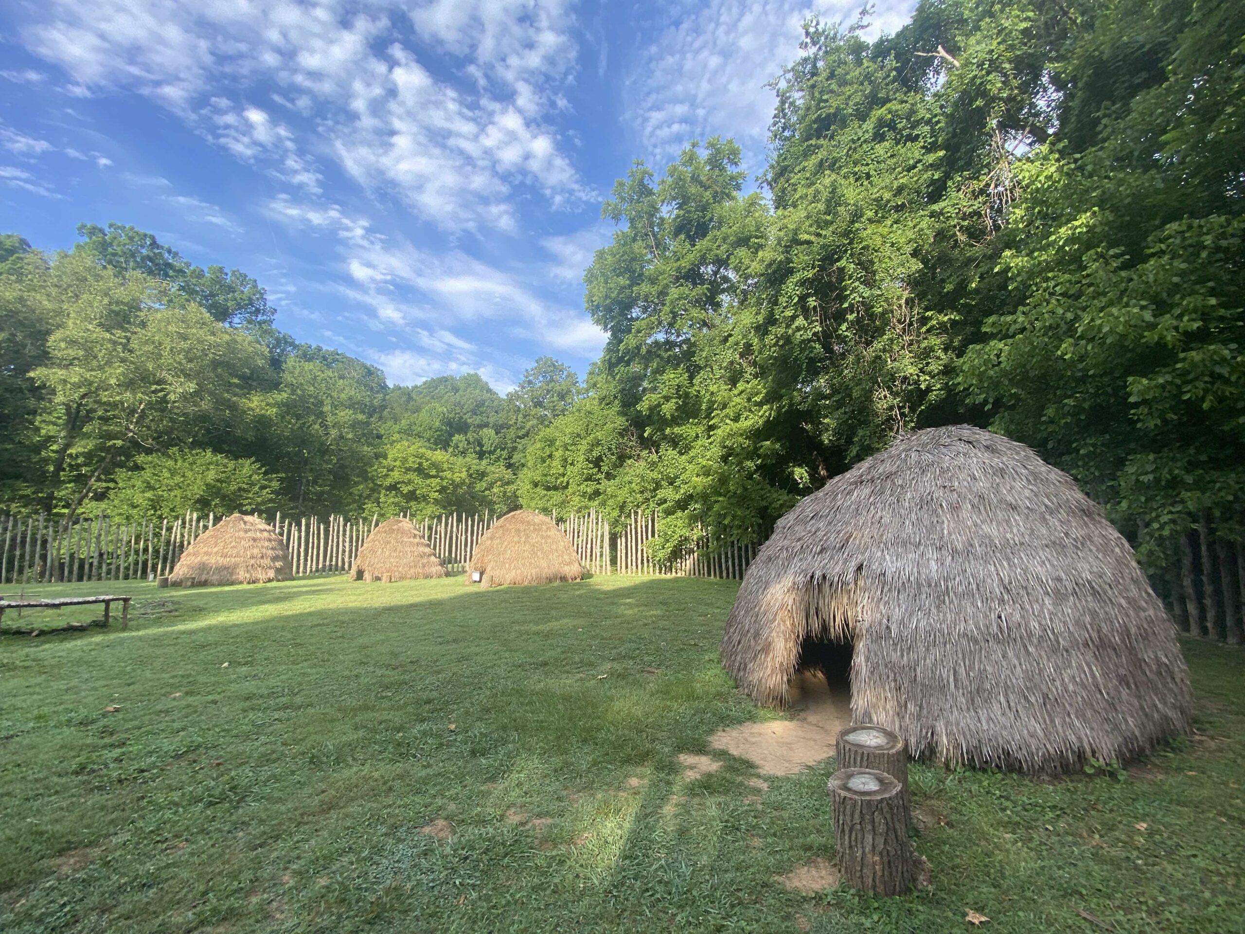
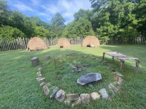
Occasionally, you’ll find a kiosk that goes into additional detail. And on rare occasion, you’ll find something along the lines of the Occaneechi Village Replica Site along the Riverwalk (a k a the Mountains-to-Sea Trail) in Hillsborough. Here you’ll find a reconstructed 17th century village of the Occaneechi band of the Saponin Nation along the banks of the Eno River. The site is a work-in-progress, but already gives a good feel for life in this fortified village (on the original site) from 300 years ago. Replica ati (huts) and communal features now exist; kiosks explaining the structures and life in the village are coming.
Native Land: Indigenous, ingenious
For the big picture, though, check out the Native Land Digital website. Native Land is a Canadian not-for-profit incorporated in 2018 that, according to the website, “strives to create and foster conversations about the history of colonialism, Indigenous ways of knowing, and settler-Indigenous relations, through educational resources … .” One of those resources: the Territory Acknowledgement Guide, a map showing who the Indigenous people were worldwide, but especially throughout the Americas.
A quick caveat about the map, from Native Lands: “We do not regard these maps as anything near a legal quality for land claims or disputes, and we do not aim to make any claims as to what territories are ‘correct’ or ‘incorrect’ in this more legal sense.” The maps are a work in progress, and Native Lands acknowledges that mistakes will occur — and be addressed in a timely manner.
How cool is the map? You can enter your address and it will bring up a list of Indigenous people associated with the area. In my case, in Hillsborough, NC, six popped up, two if which I knew (Eno, Occaneechi), four of whom I didn’t (Lumber, Saponin, Cheraw, and Shakori).
Click on the nation listed and it will take you to the home page for that nation, where you can find recent blog posts involving that tribe or nation, a map showing that entity’s extent, a website for that entity, the Indigenous languages spoken, relevant treaties and more. You’ll also find a link to corrections made to the page and “Changelog,” which lets you submit “your thoughts or fixes.” The latter will, if verified, be incorporated into the site. (The effort to be as straightforward and factual as possible on the site is especially refreshing in the internet age.)
The map is a cool feature and key to Native Land’s overall mission, which is two-fold, according to its mission statement:
“We aim to improve the relationship of people, Indigenous and non-Indigenous, with the land around them and with the real history and sacredness of that land. This involves acknowledging and righting the wrongs of history, and also involves a personal journey through the importance of connecting with the earth, its creatures, and its teachings.”
One thing we’ve found to be true in 30 years of writing about the land and leading hikes on it: the more people know about the land, the more likely they are to demand its protection.
* * *
Learn more
- For more information on Native Land Digital, visit native-land.ca.
- For more information on both the Occaneechi Replica Village, and the Occaneechi band of the Saponi Nation, go here.
- Check out the PictureThis app here.