Driving to Wrightsville Beach Friday I glanced to my right and saw an older fellow pedaling a beach cruiser. He was on a greenway paralleling Eastwood Road, which you may not think you know, but if you’ve ever driven to Wrightsville Beach, its the road that takes you across the drawbridge into the heart of WB. The man was riding in front of what looked like an upscale retirement community, the kind favored by folks who like the idea of retiring to the beach, but not on the beach. I assumed it was an amenity of the community.
But a mile later I glanced over again and saw another cyclist on the same greenway, which was now going past a shopping center. An extended greenway? I wondered.
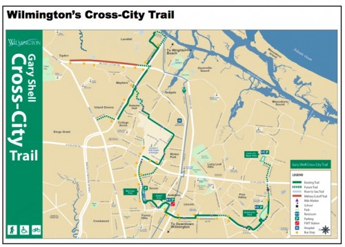
Indeed, it was the Gary Shell Cross-City Trail, the most developed of Wilmington’s evolving greenway network. The greenway begins at Wilmington’s Wade Park and follows a clockwise route through three more city parks and the University of North Carolina at Wilmington on its way to the drawbridge over the Intercoastal waterway. The first segment of the trail opened in 2008, it’s expected to be completed by 2015. About three-quarters of the 10-mile trail appear to be finished. Adjoining trails include the Military Cutoff Road Trail, which runs along its eponymous road to the Ogden community.
My first thought upon seeing the greenway was $12. That’s how much it cost us to park the car for the day in Wrightsville Beach, a town where meter maids patrol with unparalleled tenacity. Park the car at Wade Park, get the bikes off the roof rack, hitch up the BOB to tote our gear and half a pleasant bike ride before hitting the beach. A bit mercenary, perhaps, but it demonstrates the functionality, in addition to the recreational benefit, of a good greenway.
I’ll return to Wilmington in a month or so with GPS and notebook in hand to give a more full report on the Cross-City Trail and add it to GetGoingNC’s North Carolina greenway database: Map, slideshow, description, highlights — the full treatment.
In the meantime, here’s the map from Wilmington’s Web site and a link for where to find more info on the trail.

Good excuse to get some extra exercise and save a few bucks. Maybe my eyesight is worse than most but even after clicking on the map to enlarge it, I find it a challenge to read.
I see that the link provided brings up a page with a better map. It looks like the plan is for this to be 15 miles total!:
http://www.starnewsonline.com/article/20120330/ARTICLES/120339962/1177?Title=Wilmington-looking-for-feedback-on-cross-city-trail