Editor’s note: The following originally ran in February 2018. We run it again today because it still holds true.
They’re the best trails you may not have heard of, those hikes that somehow fly under the radar.
You know the ones: You’re exchanging notes on favorite hikes with a friend and they say, “And, of course, there’s the Birkhead Wilderness.”
The what?
On the one hand, it’s exciting to learn about such trails. It’s also a bit vexing. I can’t wait to hike it, and yet, Why didn’t I know about it?
Don’t beat yourself up. Rather, lace up, do some exploring and introduce yourself. Here are five great hikes that, for whatever reason, have a tendency to fly under the radar.
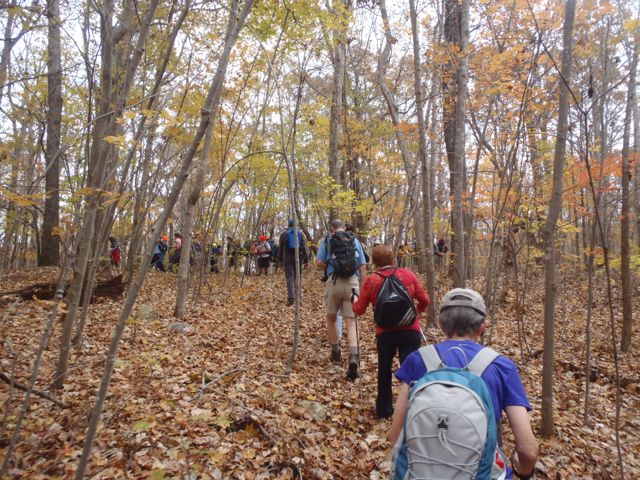
Birkhead Mountain Wilderness Loop, 7.6 miles, Uwharrie National Forest, Asheboro. What better place to start than with the aforementioned Birkhead Mountain Loop, which covers a goodly chunk of the 5,068-acre Birkhead Mountains Wilderness on the northern tip of the Uwharrie National Forest southwest of Asheboro. The trail spends most of its time along two parallel ridges, passing through maturing hardwoods that will continue to mature thanks to area’s wilderness designation in 1984. It also dips into troughs of holly and mountain laurel along Hannah’s Branch and Robbins Branch, making for a scenic contrast. Three access points to the loop result in hikes ranging from 7 miles to 12 miles.
White Pines Nature Preserve, Pittsboro. 3 miles. White Pines may have been the first property spared by the Triangle Land Conservancy (in 1987) but it has managed to remain one of its most obscure properties. They “why” of which beats us: it’s hard to imagine more diversity packed into 275 acres. The 3 miles of trail that takes you through White Pines explores a rich bottomland forest (Gilbert Yager Trail), takes you to the surprisingly rocky and roily (and wide) confluence of the Deep and Rocky rivers (River Trail) and takes you through a stretch of southern hardwoods eerily reminiscent of the Pisgah National Forest some 150 miles west.

Rock Castle Gorge, Floyd, Va. 10.7 miles. There’s actually a lot of buzz about Rock Castle Gorge, about the rigorous climb that starts the hike (hey, at least it’s at the beginning), about the vast meadows, along the ridge, about the mellow 4-mile descent at the end. About the fact there’s an Appalachian Trail shelter on the trail, even though the AT is a ways west (the trail was rerouted from here in the 1950s). You’ve got views, you’ve got the rugged intimate beauty of the Blue Ridge Escarpment, you’ve got easy access.
White Oak Mountain Wildlife Management Area, Chatham, Va., 2-3 miles (estimate). White Oak Mountain is the “What the … ?” mountain you see driving US 29 north of Danville. What the, as in “What the heck is a mountain doing here? Indeed, the mountain rises 400 feet above the surrounding farmland leading one to wonder what the heck goes on there: It’s gotta be some kind of government installation, we’re sure at least one conspiracy theorist has theorized. And it is, kinda, a 2,712-acre wildlife management area open to hunting, fishing and hiking. You’ll hike through mixed hardwoods and pines, past assorted ponds ranging in size from a half acre to six acres. It simply begs to explored the next time you find yourself on U.S. 29 between Danville and Lynchburg.
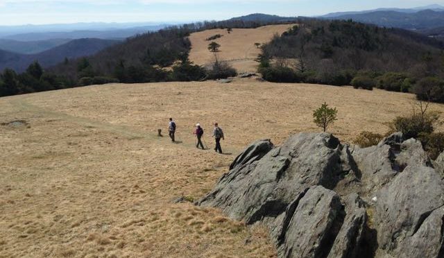
Doughton Park, Blue Ridge Parkway, Roaring Gap. 18 miles, with shorter options. To the folks familiar with the 30 miles of hiking trail at Doughton Park, this is hiking nirvana. The 7.5-mile Bluff Mountain Trail (pictured above) spends much of its time atop a ridge, entering one vast meadow after another, the Basin Creek Trail explores a deep box canyon, and the Cedar Ridge, Bluff Mountain Primitive, Grassy Gap and Flat Rock Ridge trails spill down the Blue Ridge Escarpment through forests of old hardwoods and mountain pines. A favorite circuit: from the access off Long Bottom Road, get most of your climbing out of the way early by ascending Cedar Ridge. At the top, head south on the Bluff Mountain Trail to it’s conclusion, then return to the trailhead via Flat Rock Ridge (Grassy Gap also makes for nice return that’s a mile shorter). 17 miles total.
* * *
Take action!
For details on the five hikes mentioned above, click the link.