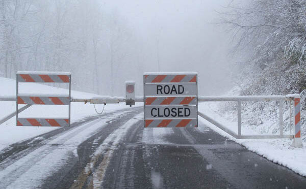
The winter sky is dry and clear, the temperature cold, invigorating. It’s the perfect weather for a long mountain hike. Then, your car loaded with gear and enthusiasm, you find your travels and day-hike dreams shattered by those two little words on a barricade baring access to the trailhead:
Road closed.
It happens in the Southern Appalachians this time of year. It happens frequently on the Blue Ridge Parkway, off of which you’ll find 369 miles of hiking trail, including a couple hundred miles of the Mountains-to-Sea Trail. It happens along 105-mile Skyline Drive through Virginia’s Shenandoah National Park. National Forest access roads can close after a good snow, and while snow removal on highways and roads is generally pretty, short closures can happen. And more than weather can keep you from your destination: construction, accidents, landslides can all close roads, or at least reduce traffic to stop-and-go, increasing your time behind the wheel and minimizing the time your behind is on the trail.
Fortunately, it’s pretty easy to get current information on road conditions in the Southeast. Below, we list the major road systems we use to access trails and provide a link and a description of the kinds of helpful road information you can find.
- Blue Ridge Parkway: The thing about the Parkway is that very little of it is maintained in winter: when it does snow or an ice storm hits, the parkway is closed until it melts. Even if there hasn’t been a storm through in a week or more, the parkway, especially its higher reaches — say, from Mount Pisgah west to Waterrock Knob, or from Asheville to Mount Mitchell — can stay closed for long stretches, depending upon the weather. A super-handy feature on the BRP website is a map showing real-time road closures. Stretches of the parkway showing green are open, if it’s red its closed, if it’s yellow it’s under an advisory (fog, for instance). In a column on the left side of the screen you can click on one of 14 areas along the parkway and drill down to that area, simplifying your search. (That wasn’t necessary Monday: after another winter storm rolled through nearly all the parkway was closed from Cherokee north to Roanoke, Va.) This information is also available in a chart broken down by crossroads and mileposts. Here, you can tell the reason for the closure as well.
- Skyline Drive Virginia’s Skyline Drive does not have a similar real-time road-closure option online. Rather, for road conditions on this 105-mile road through Shenandoah National Park, call: 540-999-3500, option 1, option 1
- Great Smoky Mountains National Park. There aren’t a lot of roads in this half-million-acre National Park, and many of the roads therein have seasonal closures (find those here). Follow current road status updates on Twitter at SmokiesRoadsNPS. Updates are available for Newfound Gap Road (US-441), Little River Road, Laurel Creek Road, and Cades Cove Loop Road.
- NCDOT North Carolina’s real-time road conditions map includes various layers: you can check by type of road (Interstate, US highway, State Route, Secondary Road), by county, by traffic cameras. You can check to see where there’s current congestion, from construction, from accidents, whatever. One place I find this especially helpful is getting to the mountains on I-40 west of Winston-Salem. More than once I’ve abandoned the interstate for US 70 or 64 to avoid long stretches of stop-and-go.
- VDOT: The Virginia Traffic Information map also includes a variety of layers. Among the helpful tools we especially like is one that lets you judge congestion by traffic speed. Click on “Speeds” and roads where traffic is proceeding at 40 percent or below the posted speed limit will appear black; if people are driving between 40 percent and 60 percent of the speed limit the road will show red, 60-80 percent yellow, and 80 percent or above will show as a green road. There’s also an overlay for Precipitation — rain, ice, snow, a mix — and for road conditions.
- TDOT: Tennessee’s SmartWay program is where you can find weather-related issues and Traffic Delays by degree: click on the Traffic Delays function and the roads appear green for No Delays, orange for Moderate Delays, red for “Traffic” Delays, a deep crimson for Heavy Traffic Delays. It also includes a Waze function with real-time info.
- SCDOT: South Carolina’s 511sc site provides some of the same information plus driving directions, including the quickest way to reach the beach.
Unless you’d rather be listening to books on tape in gridlock than hiking, make friends with these resources and use them before heading out on your next adventure.
In a nutshell
Here are the key links mentioned above to help you effectively, quickly and safely navigate your way to the trailhead.
- Blue Ridge Parkway: Realtime Road closure map
- Skyline Drive: call 540-999-3500, option 1, option 1.
- Great Smoky Mountains National Park:
- NCDOT: Real-Time Traffic Conditions here
- VDOT (Virginia): Virginia Traffic Information
- TDOT (Tennessee): SmartWay
- SCDOT (South Carolina): 511SC
This week on the GetHiking! Southeast Podcast
Learn more about checking on road closures plus how to explore North Carolina’s Game Lands, in today’s episode of the GetHiking! Southeast Podcast, here.