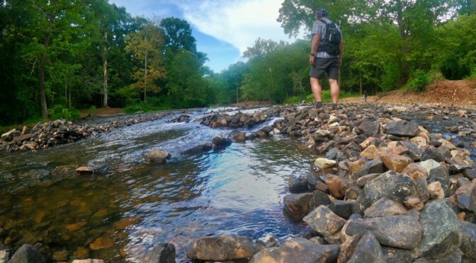
I stood atop the outcrop overlooking New Hope Creek this morning and was reminded of how much I liked this particular trail. Moments later, as I continued upstream through Duke Forest, I was reminded of why I‘d never included this hike in our GetHiking! Sunday hike series.
I reserve Wednesday mornings for scouting; I’ll elaborate shortly, in a post from 2018. As a lead-in, I’ll highlight one of the reasons I scout trail, the reason I was out this morning on the Hanging Rock Trail at Hollow Rock Nature Park in Durham, then on trail in an adjoining section of Duke Forest.
 Sunday, we have a hike scheduled on about 5 miles of trail originating in Hollow Rock. Since I hadn’t hiked the trail in a couple years, I needed to check it out before leading a group — two, actually. Specifically, I was out to make sure …
- … the route was open. Trails can close for a variety of reasons, especially in Duke Forest, a research forest consisting of more than 7,000 acres in three counties. Sensitive project underway? Trail closed. The forest also closes for wildlife thinning (usually weekdays in the fall) from time to time. Finding: the route was open.
- … there was no downfall or other obstructions making passage difficult. A trail could have recent storm damage and still be open. However, it might take some gymnastic maneuvering to get through. Finding: no storm-related obstacles.
- … the trail wasn’t flooded or mucky. The trail spends most of its time along New Hope Creek, in a floodplain. Though it hasn’t been rainy of late, it still needed checking out. Finding: a damp spot or two, but mostly dry.
- … the one creek crossing was passable. There’s a feeder creek a mile and a half in that typically has water. In summer, there’s a crossing a hundred yards upstream that’s dry enough to cross. This time of year, it’s iffy. Finding: the crossing was iffy, but that proved irrelevant because the trail flunked test No. 5 —
- … the trail was as I remembered it. Parts of it were, but somehow I’d blocked out the not long, but frequent rocky stretches that were surprisingly technical — and in one instance steep. In this particular hike series, folks are looking for a nice, 5-mile-or-so ramble in which they can chat and enjoy the scenery, not one that demands their constant attention. Finding: Find another hike.
Which I did, one more in keeping with the spirit of this group.
That’s the story from this morning’s scouting trip. Now, on to a look at scouting in general, taken from a post originally appearing Dec. 6, 2018.
* * *
Today is a scouting day. Of my many tasks as a hiking guide, scouting the trail in advance is among my favorite. If I’m leading on a trail I haven’t hiked in a year or longer, I go out beforehand and hike it. I like to make sure the trail is passable, that a hurricane hasn’t laid a stand of trees across the trail, that recent rain hasn’t turned a key crossing into a Class III rapid, that—in the case of a National Forest—the trail hasn’t been closed for logging or another form of resource development. As a guide, I don’t like surprises when trying to get hikers from Point A to Point B safely.
For hikes we do in state parks, nature conservancies, municipal parks, the element of surprise is low, even before a scouting trip. Most land managers post trail disruptions on their websites. Even the USDA Forest Service posts advisories on its more heavily traveled trails. Additional pre-hike insight comes from websites such as alltrails.com and hikingupward,com, where hikers sometimes leave comments on recent trail conditions.
It’s a different story, though, when you’re hiking the trails less traveled, and the trails that don’t exist at all.
Scouting off trail
Trails that aren’t officially trail are what we’re focusing on in a series of Winter Wild hikes. They may start on established trails, but they won’t stay there for long. For the most part, we’ll stick to game trails and long-abandoned wagon tracks to explore the hidden human history and natural gems of the state parks and national forests. Scouting these trails is especially critical to a safe and successful hike.
The scouting trip I’m on today is at the coast. I first became aware of the Weetock Trail in early 2006 while researching “100 Classic Hikes in North Carolina” (2007, Mountaineers). Coastal trails being at a premium, I was eager to include what, at 11 miles in length, was the second longest trail at the coast. However, I was unable to find the trailhead, which was somewhere off N.C. 58 between Maysville and Cedar Point. If I couldn’t even find the trailhead, it wasn’t a good candidate for a trail guide aimed at a general hiking audience.
A few years later, armed with directions, I did find the trailhead (which now had a marker) and had little trouble finding and keeping the trail for the first six miles or so. I passed the gravel road to Haywood Landing after about three and a half miles, as promised. A little while later, I bumped up against the White Oak River, which my map suggested would happen. And I’m pretty sure I had passed the unmarked road leading to Long Point Landing, about six and a half miles in.
There was trail, then there wasn’t
Then, I emerged from the edge of a pine forest into a long-abandoned farm field, now a sea of unfettered wild grass standing three feet high that gave no clue as to where the Weetock continued. On the far side of the field, where the forest resumed, were several promising openings where the trail might resume. Eventually, I discovered a trail: unmarked, I could only guess that it was the Weetock and not a game trail, not a hunter’s trail. Whether it was or not is hard to say. The forest/field/forest scenario repeated, and this time the existence of a trail was less certain. But I continued, assured by my compass that I was at least headed in the right direction.
I hoped that I would stumble across an obvious trail. I never did. Sunlight was becoming an issue, and I was relieved, with dusk settling in, when the woods spit me out on a gravel forest access road. I checked its direction with my compass — northeast — and based on the fact this was only the third access road I had passed, I was pretty sure this road would take me straight back to NC 58 not far from the trailhead.
The next day, I went to find the southern trailhead, with the idea of hiking in the opposite direction and discovering familiar terrain to discover where I had strayed. Alas, I couldn’t find the southern trailhead, or anything resembling a trailhead. No roadside pullout, much less a “Welcome to the Weetock” trail sign.
So today, I try again. I’ve got two paper maps (including the alltrails.com map pictured above). I’ve got updated software on my Garmin GPS and I’ve got Google maps on my iPhone (which has more than once aided my escape from a backwoods wander gone awry).
* * *
GetHiking! Spring Sunday Series
 In the next couple of days we’ll be ramping up our scouting for our Spring Sunday Hike Series, 10 Sunday hikes on different trails with the added benefit of watching spring unfold. Each hike is about 5 miles. Learn more about our Spring hike series and register to join us, here:
- GetHiking! Spring 2022 Sunday Afternoon Hike Series (couples/family), go here.
- GetHiking! Spring 2022 Sunday Afternoon Hike Series (single hiker), go here.
- GetHiking! Spring 2022 Sunday Morning Hike Series (couples/family), go here.
- GetHiking! Spring 2022 Sunday Morning Hike Series (single hiker), go here.