These days, you find adventure where you can — provided it’s close to home.
Personally, I’ve established a 10-mile perimeter for how far I’ll go, for the most part, for a good adventure. (I say “for the most part,” because if there’s an adventure to be had that’s slightly beyond that, I’ll go if the odds of encountering others is slim to none. So far, I’ve breeched my 10-mile containment zone once, a paddle trip that easily complied with social distancing standards.)
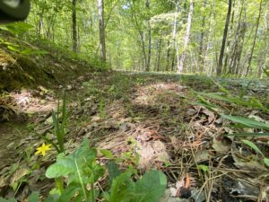
This past Wednesday, I set my sights on an adventure with one simple goal: avoid people. So I headed down NC 751 in Durham, a 3-mile stretch of two-lane bound on both sides by Duke Forest with 15 separate trailheads. Some provide access to trails that are maybe a quarter-mile long. Others open onto as much as 4 miles of trail. Surly one of the roadside pullouts would be empty, I thought. After passing a dozen that weren’t, I hit the jackpot: Gate 11.
Gate 11 leads to the largest run of connected trail in this stretch, including passage south to Cornwallis Road. But the big prize of Gate 11: Couch Mountain.
Ordinarily, a 1.6-mile trail that gains less than 150 vertical feet wouldn’t get my “thrill-of-victory-agony-of-defeat” juices flowing. Nor would the prospect of planting my flag on a 640-foot “peak.” But these aren’t ordinary times, and when I realized I had a chance to bag one of the highest peaks in Durham County (770-foot Red Mountain being the county’s apex), my juices began to flow.
I won’t go into detail about my successful summit bid; you can catch the highlights in the attached 3 minute and 33 second video. It ain’t “Free Solo,” but it is an example of the kind of adventure to be had in your own backyard in these stay-in-place times. It’s also an example of how it’s good to find and appreciate our smaller, simpler escapes.
What’s in your backyard?
On the topic of finding those adventures, here’s a quick primer from our just-released “Explore Your Neighborhood: A Guide to Discovering the World Immediately Around You.” First, fire up Google Maps. Then:
- Begin with a distance you’re comfortable traveling, both walking from your front door and within a short drive (my comfort zone, again, is 10 miles). To determine distances, call up Google Maps, then, in the menu bar, click on “Your Places.” Click on “Maps,” then “Create Map.” You’ll get a map of the U.S.: keep double clicking on “North Carolina” until you get down to your neighborhood. Then use the distance tool — ruler icon — to determine crow-fly distances from where you live.
- Look for splotches of green. They may be golf courses or cemeteries, or they may be parks. Keep in mind that while some parks are closed, many have closed only rec centers, restrooms, playgrounds and other physical facilities;:their trails and open fields may still be open.
- Look for green dashed lines. Green dashed lines indicate a natural surface hiking trail.
- Look for solid green lines. These often indicate a paved walking trail.
- Look for green pins with trees in them. Some parks are marked with these.
- Look for streams and creeks. Greenways and trails sometimes parallel waterways. Even if there aren’t actual trails, you may find fishing paths or game trails that offer access. Even if these paths don’t go far, they make for a nice diversion into the natural world.
With a little scouting and the right attitude, you can find an adventure you didn’t know was within reach.
Get out this weekend and bag your own Couch Mountain.
* * *
Resources
-

“Explore Your Neighborhood” “Explore Your Neighborhood: A Guide to Discovering the World Immediately Around You,” is our just-published guide to doing just that. It’s compact, just 54 pages because you want to spend less time reading about exploring, more time doing so. It starts with how to scout your neighborhood, then suggests how you can plot your own adventures. Available in ebook and paperback.
- Exploring Duke Forest. Duke Forest consists of more than 7,000 acres in six divisions (and one natural area) in Durham, Orange and Alamance counties. Finding access can be a challenge, and unfortunately, sales of the map packet have been suspended due to COVID-19. However, you can check the overview map of the forest on its website, then cross reference it with Google Maps, where you’ll find most of the trailheads.