Today’s post is a follow-up to last week’s post on backpack trips we intended to take in 2020, but couldn’t because of the pandemic.
Face it, are there no bad hikes. Each hike has its own special, well, “charm” may be pushing it. But each hike we do does have some unique or compelling aspect that, in the end, always has us saying, “That sure beat a day at the widget works.” Even when it’s finger-nipping cold, even when it’s wet enough to pack a snorkel.
Still, there are some hikes that stand above the rest. A grand view, perhaps. Fabulous fall color, or an especially inspiring spring wildflower display. The hikes that we put an asterisk next to in our hiking journals and vow to hike again, soon.
For us, “soon” was supposed to be last year. Our planned hike schedule — a scheduled planned in January, when planning still made sense — included several hikes we were especially excited about. Hikes that we try to hit regularly, for reasons specific to that trail.
Today, we share five of those hikes, along with the reason they’re special to us. In the Hike It Yourself section at the bottom, you’ll find information on how to hike each trail yourself.
1. Mount Mitchell Trail
5.6 miles (one way, 11.2 miles up and back)
Black Mountain Campground, Burnsville
The allure: With 3,700 feet of vertical it’s great for assessing your fitness; a state of the union for hiking, as it were
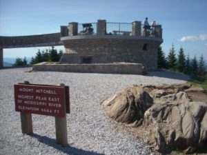
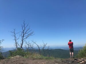
I look at this as an annual assessment of where I stand as a hiker, especially whether I’m losing anything and need to start making it up. This hike is just 5.6 miles (OK, it’s an out-and-back so make it a little more than 11) but it’s less the length than the elevation gain — about 3,700 vertical feet, and without much recovery opportunity to catch your breath: it’s pretty much a slog straight up. It’s not until you’re near the top, once you enter the boreal forest at close to 6,000 feet that it becomes challenging. The trail gets a little steeper, the terrain becomes rocky and rooty. Still, you’re within a half mile or so of the summit, which eggs you on. One bummer: share your summit victory with a hundred or so “hikers” who’ve walked the length of a mall, from the gift shop. Still, at an elevation of 6,684 feet you are now standing at the highest point on the East Coast, the highest point east of the Black Hills of South Dakota. You’ve earned the bragging rights, not driven them to the summit.
2. Sam Knob Loop
8.2-mile loop
Black Balsam area of the Blue Ridge Parkway
The allure: The grandeur of its neighbor Shining Rock minus the crowds
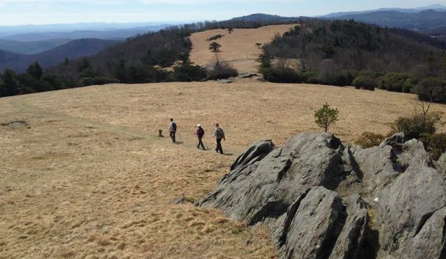
There are places you love to go, and there are places you love to go that everyone else loves to go, too. Once you’ve identified an area of mutual and multiple adoration, it’s time to find a suitable alternative. The Shining Rock area of the Pisgah National Forest is a prime example: Between Shining Rock, Graveyard Fields, the Art Loeb Trail, and Black Balsam, it’s hard to find any peace — let along a parking spot — at the main access to Shining Rock, the Black Balsam parking area just off the Blue Ridge Parkway. Enter “Shining Rock” into the AllTrails.com app and you’ll get 131 curated trails. While two or three of these recommendations include portions of the Sam Knob Area located adjacent to Shining Rock, none are the 8.2-mile Sam Knob Loop. You don’t even need to use the busy Black Balsam parking area to access the trail; rather, sneak in the back door off NC 215 and hike in from the west. Hike it clockwise and you’ll hit Chestnut Bald, Little Sam Knob, Sam Knob, Flat Laurel Creek, some nice cascades, some boreal forest, sweeping views — basically everything you’ll find at Shining Rock minus the legions of blueberry pickers and youth groups that storm the area from late spring into fall.
3. Doughton Park Loop
17-mile loop
Longbottom Road Access to Doughton Park
The allure: A challenging, yet doable, 17 miles in one day
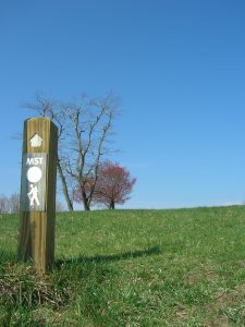
Is it possible to do a 17-mile day-hike that climbs and retreats down the face of the Blue Ridge Escarpment? Granted, you need to be in OK shape — this is a hike for folks who get out regularly and probably have a recent 10-miler under their belt. But I’ve led numerous groups on this hike and they’ve all finished. Now, if you’re familiar with Doughton Park, you’re likely familiar with the Blue Ridge Parkway portion of the hike. The part where multiple access points let you hike through open mountaintop meadows with grand views. You get those views with this version of the hike, but you don’t start and end with them. Rather, you begin at the base of the Blue Ridge Escarpment and climb 4 1/2 miles up the Cedar Ridge Trail: steeper at the beginning, tapering some near the top. With 75 percent of your climbing behind you meander on the Bluff Mountain Trail (which is also the Mountains-to-Sea Trail) four another 4 1/2 miles through those rolling meadows, then three miles of quiet hardwood forest before the nearly 5 mile descent back to the car. This is a popular training hike for hikers in the Triad and Triangle: it’s a good challenge delivered with lots of distracting scenery.
Standing Indian Mountain
11.1 miles
Standing Indian Recreation Area, west of Franklin
The allure: A challenging mission, a suitable reward
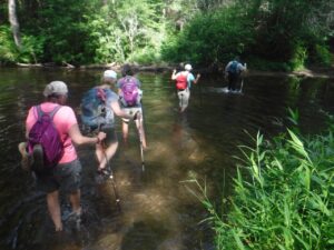
 I love a good, straightforward hike with a clear plan and a challenging objective and, at hike’s end, winds up with me sitting in a camp chair in a mountain stream drinking a beer. That’s what you get with this classic 11.1-mile hike that follows a mountain stream for 4 miles to a gap, then picks up the Appalachian Trail for a 2.5-mile climb to a mountain with a view. 5,513-foot Standing Indian Mountain makes for a great summit lunch stop with gazing to the south and east into a vast landscape about as devoid of signs of man as any in the southeast. Lunch up here on a clear day … man, it’s the best. There’s a 4.5-mile return that “trends downhill” (guide-speak for, There may be a short climb or three along the way; don’t hold me to it). Finally, at hike’s end back at the campground, a celebratory brew in Kimsey Creek. Plan to make a few days of it by staying in the Standing Indian Campground and executing several similar hikes that use forest service trail to create loops with the AT, which forms something of a horseshoe on its passage through the area.
North Mills River
9.5 miles
North Mills River Recreation Area, Mills River
The allure: The charm and challenge of the nearby Davidson River area, minus the crowds
Years ago I planned to lead a hiking weekend in the Davidson River area, only to realize at the last minute that I hadn’t reserved campsites. Big mistake at the popular Davidson River Campground, where the reservable campsites are snapped up weeks in advance and the lines for the first-come sites resemble those for Duke/UNC tickets. I frantically began searching for an alternative and up came North Mills River, just a ridge or two to the east. The fact that they had openings made me dubious — I was even more so after arriving to find a voluminous meadow camping area with out-the-tent-door access to great hiking. We especially liked the hike up Fletcher Creek to Spencer Gap, with a return down Trace Ridge. It was August and the multiple creek crossings on Fletcher Creek were especially welcome, as was the exceptionally mature forest above Hendersonville Reservoir.
Hike it yourself
Itchin’ to hike these trails yourself? Resources to get you started follow.
Mount Mitchell Trail
- Find the Alltrails.com route description here.
Sam Knob Loop
- “Backpacking North Carolina,” Trip No. 14
Doughton Park Loop
- Visit the National Park Service site here for information on Doughton Park and a map
- “Backpacking North Carolina,” Trip No. 11
North Mills River Loop
- Visit the National Forest Service site for North Mills River here
Standing Indian AT Loop
- Visit the National Forest Service site for Standing Indian here
GetHiking! Southeast Podcast
 This week on the GetHiking! Southeast Podcast we discuss the hikes mentioned above plus two more hikes we hope to do in 2021. We also look at North Carolina’s record State Park attendance in 2020. Give a listen here.