This morning I awoke to a temperature of 63 degrees. I couldn’t remember that last time it wasn’t in the mid-70s when I got up — weeks, at least — let alone in the low 60s.
It was a sign, a sign I always look forward to come August: that fall is on the way.
It’s also a sign that summer will soon be over.
While I so look forward to fall hiking after a summer of sweaty heat, I also get a bit nostalgic over the passing of summer. Especially if I haven’t taken one of my go-to summer adventures. That is, an adventure that’s best taken in the heat. Maybe because there’s an abundance of water to play in. Maybe because the elevation lets you escape the heat. Or it may be as simple as the fact the trail can be challenging to reach in the snow and ice of winter.
So what are my summer go-tos? Glad you asked.
Here, in no particular order, are five of my favorite summer adventures — adventures you might consider putting on your list before summer bids farewell.
Wilson Creek
Water, water everywhere could be the slogan for Wilson Creek, which resides at the base of Grandfather Mountain’s southeast flank and is catchment for the massif’s ample runoff. Wilson Creek proper gets most of the summer attention: avoid it. Rather, take FR 464, a windy gravel road to two trailheads in the Lost Cove region:
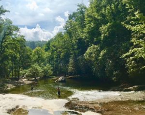
- Hunt-Fish Falls Trailhead. Pick up the Mountains-to-Sea Trail and head downhill 0.8 miles to the trailhead’s namesake falls, a double drop that results in a sizable rock-rimmed pool. Continue downstream on Little Lost Creek on the MST, then upstream on Gragg Prong for about 2 miles where you’ll begin to encounter a series of falls and pools. So many that even on a gorgeous summer weekend you’ll have one to yourself. Challenging hiking with a more than ample pay-off. Details here.
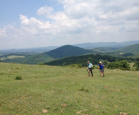
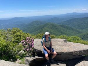
- Big Lost Cove Trailhead: About 4 miles up from the Hunt-Fish Falls trailhead you’ll find the Big Lost Cove Trailhead. It’s a 1.7-mile hike in, with elevation in the first half mile. From there. it’s mostly ridgeline hiking before a minor descent and short hike to one of the best views in the state, including the valley below and Grandfather Mountain beyond. Details here.
Note: Because navigating the area can be tricky, you might make your first stop the Wilson Creek Visitor Center, 7805 Brown Mountain Beach Rd., Collettsville, 28611, and get directions for the 25- to 30-minute drive to the featured trailheads from there. Find a map to the VC here.
Mount Mitchell
Elevation and access drive the desire for a summer visit to Mount Mitchell, at 6,684 feet the highest point east of South Dakota’s Black Hills. Two recommended adventures
- Mount Mitchell Trail. Looking for a good workout and some climbing cred? The 5.6-mile Mount Mitchell Trail gains about 3,700 vertical feet in 5.6 miles, making it one of the more stout climbs in the Southeast. Yet with the exception of one short stretch two-thirds of the way up, well-designed switchbacks make the climb less onerous than it might sound. Start in a robust Southern Appalachian hardwood forest outside the Briar Bottom Group Campground, end in a boreal forest more common to Canada than the Carolinas. Details here.
- Black Mountain Crest Trail. If you’re not so much into a workout, drive to the top and, from the snack bar parking lot in Mountain Mitchell State Park, head north on the Black Mountain Crest Trail. Five, 6,000-foot peaks await in the first 3+ miles, to Deep Gap, but don’t expect to summit them all: hiking along the spine of the highest range on the East is slow going, with lots of up-and-down over rocky terrain. So many great views, though, and the best is the first, from Mount Craig, a mile in. Details here.
Mount Mitchell State Park address: 2388 NC 128 (Burnsville is listed as the mailing address; it is, in fact, a good 45-minute drive, so don’t be deceived). Here is a Google Map .
Rocky Knob Recreation Area
 Possibly my favorite summer hike is the 10.7-mile Rock Castle Gorge Loop in the Rocky Knob Recreation Area along the Blue Ridge Parkway in Virginia. For maximum enjoyment, start at the base, on the trailhead off VA 8 (CC Camp Lane), and hike counterclockwise. This gets the bulk of the climbing out of the way in the first 4 miles — though you likely won’t notice it as you start in a stunning mature Southern Appalachian hardwood forest, then hit the mountaintop meadows with miles of views (and cows). Several great places to stop for lunch before a rocky descent down to Rock Castle Creek. Your legs may be screaming uncle at this point, but worry not: the last three miles is a gentle descent on old roadbed back to the car. Details here.
The trailhead has no address and can be tricky to find: Here are the GPS coordinates — 36.80806, -80.33087 — and a map.
Mount Pleasant National Scenic Area
 Have you ever been on a hike and thought, “Man, this is darn-near perfect”? That’s what you’ll find in the 7,580-acre Mount Pleasant National Scenic Area in Virginia’s George Washington National Forest. The-hills-are-alive meadows, tranquil forest, quiet and a great view from atop 4,071-foot Mount Pleasant make this a summer must (mainly because the Wiggins Spring Road access is windy, gravel and can be a challenge in snow and ice). From the main trailhead, you have two options:
- Mount Pleasant Loop. This 6.3-mile loop includes the view: about mid-way through there’s a short but challenging spur that leads you to the outcrop summit of Mount Pleasant. The rest of the hike ain’t too shabby, either, consisting mostly of intimate forest passage. Details here.
- Cole Mountain Loop. From the same Wiggins Springs Road trailhead, hike west a short distance on the road to where the Appalachian Trail crosses, then head south. Switchbacks take you up to Cole Mountain, where you’ll hike a ridge for a bit before dropping down to the Hotel Trail. A mellow drop to a stream, a rise to a grassy meadow, a gentle drop back to the trailhead. Details here.
For more about the Mount Pleasant National Scenic Area in general, go here.
Appalachian Trail at Hot Springs
To be honest, we hike and backpack this stretch year-round — Hot Springs’ comparatively low elevation of 1,332 making it inviting regardless of the season. Two things we like most about the AT at Hot Springs: the classic AT experience, and the carrot at the end, which is Hot Springs and it’s brew pub, it’s great outfitter (Bluff Mountain Outfitters), and its diverse dining options, from burgers to bourbon glazed salmon. Our two favorite hikes:
- AT: Garenflo Gap to Hot Springs. Catch a shuttle from Hot Springs (lots of options; Bluff Mountain Outfitters can hook you up) to Garenflo and hike 7.4 miles back into town. There’s a little climbing, mostly at the beginning, but mostly classic southern AT beauty on a downhill-trending hike. Note that that “trend” becomes pronounced on the steep drop into town. Details here.
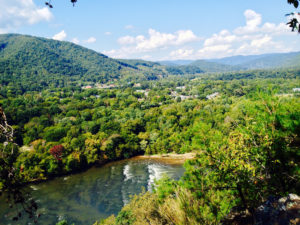
- Rich Mountain Loop. Starting and ending in Hot Springs, we suggest hiking this loop counterclockwise, sticking with the AT after crossing the French Broad River. There’s a good but short climb (0.8 miles total) up to Lover’s Leap, with great views of the French Broad valley, then more mellow climbing past Tanyard Gap (mile 5.5) and up to Rich Mountain. After checking the fire tower view atop 3,668-foot Rich Mountain, retreat a half mile and pick up Roundtrip Ridge Trail for a welcome descent back to the valley floor. A 12.3-mile loop that can be amended in various ways, including shuttling the short distance up to Tanyard Gap and hiking mostly downhill for 5.5 miles back into town. Details here.
Learn more about Hot Springs here.
Only 21 days remain until Labor Day weekend and the spiritual end of summer. Make the most of it.