Monday — never an easy time for the outdoors enthusiast. After a weekend of adventure, returning to the humdrum work-a-day world can make one melancholy. To help ease the transition, every Monday we feature a 90 Second Escape — essentially, a 90-second video of a place you’d probably rather be: a trail, a park, a greenway, a lake … anywhere as long as it’s not under a fluorescent bulb.
Tag Archives: Johnston County
5.5 miles of Johnston County greenway open along Neuse
“Do you know how far this goes?” the grade schooler on the Razor scooter asked as he scouted the greenway.
“It goes five and a half miles,” I said as I wrestled my bike off the roof rack.
“Five and a half miles?!” he repeated. “Wow!”
I caught myself as I noticed his mom standing nearby before adding, “And if you don’t mind breaking the law, you could go another five and a half.”
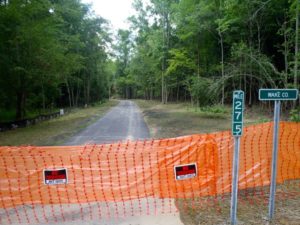
We were in a gravel parking lot off North O’Neil Street in Clayton, the trailhead for the Sam’s Branch Greenway. The 1.2-mile Sam’s Branch runs south, then east to the Neuse River, where it connects with a 4.3-mile stretch of now-open greenway that reaches the Wake County line, for a total run of 5.5 miles. There, a sturdy 3-foot-high wall of orange No Trespassing webbing emphatically blocks the trail, which was paved as far as the eye could see (about 200 yards).
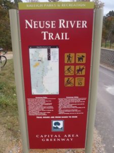
That stretch marks the beginning of Raleigh’s Neuse River Trail, a partially completed work-in-progress that eventually will run upstream for 28 miles to the base of the Falls Lake dam. The 5.7-mile stretch runs from the Johnston County line north to Auburn Knightdale Road. It’s scheduled to open in October.
For those of you without calculators, that would be 11.2 miles of continuous greenway when the finished Auburn Knightdale stretch links with the Johnston County greenway.
This section will be especially enticing for greenway users seeking solitude. Unlike the northernmost 6.5-miles stretch of the Neuse Trail, from Falls Lake dam downstream to the WRAL Soccer Complex, which opened last October, the southern segment travels through more rural, less-developed country.
Check back Monday for a quick video escape down the new Johnston County stretch. And return next week for more updates on the Neuse River Trail and on Raleigh’s House Creek Greenway.
View Clayton/Johnston County Greenway in a larger map
Raleigh’s greenway system: 2014 and beyond
Within two years, here’s how your day on the Raleigh greenways might look.
You start out on a bike ride at Lake Johnson. Park at the boathouse and take a leisurely (except for the hills on the lake’s south side) lap around the lake before heading down Walnut Creek through N.C. State’s Centennial Campus taking note of all the new construction. Stop at the Farmer’s Market to see if the strawberries are in yet, then continue downstream on some of Raleigh’s oldest greenway. Pass the abandoned E.B. Bain water treatment plant, swing by the Walnut Creek Wetland Center, pass through Worthdale and Walnut Creek parks and head on down to the Neuse River.
Raleigh’s Neuse River Trail: Another 3.5 miles by August, 16.1 miles by November

Three and a half miles of the Neuse River Trail is expected to open in August, another 8.7 miles in October and 7.0 more miles in November; coupled with the 6.5 miles opened last fall, the 28-mile greenway running along its namesake river from Falls Lake south to the Wake County line will be more than 90 percent done, at 26 miles. The entire trail, according to Raleigh greenway planner Vic Lebsock, should be done by mid-July 2013.
Triangle two ramps shy of a 60-mile hiking trail

The Triangle is two ramps away from having a 60-mile hiking trail.
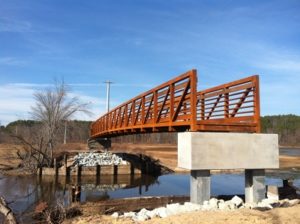
Just before Christmas, contractors using a really big crane lowered a steel bridge onto concrete footings spanning Little Lick Creek at Falls Lake. The bridge will join Sections 14 and 15 of the Falls Lake portion of the Mountains-to-Sea Trail, and will make it possible hike undisturbed from Pennys Bend on the Eno River in Durham County downlake to the Falls Lake dam in Raleigh — when it’s completed.
“When it’s completed,” because there’s still the matter of those two ramps. While Little Lick Creek lives up to its name, it’s in a floodplain that is wide. Thus, the bridge’s deck sits about seven feet off the ground, and lead-up boardwalk ramps are required.
“The contractor has until February 10 to install the ramps,” Friends of the MST Executive Director Kate Dixon said yesterday. “But I think it will be done before that.”
Initially, the plan was to save money by having volunteers build the bridge. (Except for more involved projects such as this, the 1,000-mile-long statewide trail, a little over half of which is completed, is being built by an army of volunteers.) But Dixon said they had money left over from the two grants used to fund the bridge — $150,000 from the state’s recreational trails program and $55,000 in Durham open space funds — so they decided to hire the work out.
A formal dedication ceremony is scheduled for May 19.
While the 60-mile trail will be one of longest urban trails in the nation, it’s just over a third of what the trail eventually will be. On its journey from 6,643-foot Clingman’s Dome on the Tennessee border to Jockey’s Ridge on the Atlantic, the MST will spend 150 miles in the Triangle, running from Clayton in Johnston County to Hillsborough in Orange County. That entire 150-mile stretch could be completed next year.
A progress report, from east to west:

