Winter is a season disliked more in anticipation than in reality.
That dislike begins the first day of summer. Though we generally do spend the summer solstice reveling in the most daylight of the year — 14 hours, 35 minutes and 8 seconds — in the back of our minds we know that it’s all downhill from here. The day after the solstice we’ll be down to 14 hours, 35 minutes and 6 seconds, two seconds that we won’t actually notice, but two seconds that we’re shorted all the same. read more
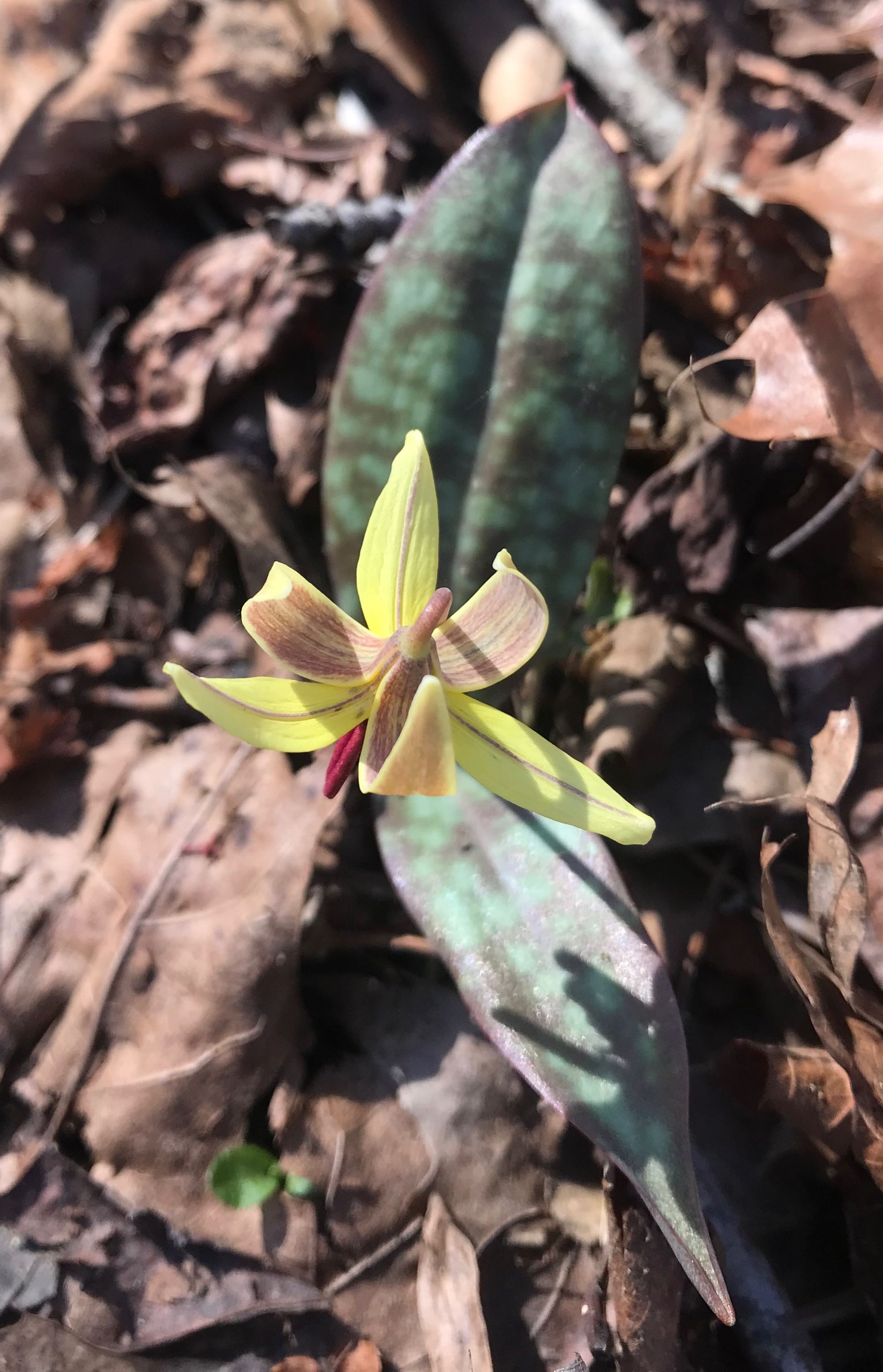
It started two weeks ago with a serenade by spring peepers in a pond at Horton Grove Nature Preserve. It was reinforced a day later by the sudden appearance of perky yellow daffodils near an old homestead along the Eno River. Then, last Friday, on a hike through bottomland forest at Ayr Mount in Hillsborough, I got the sign I’d been waiting for: a trout lily unfurling its delicate yellow and maroon petals.
The first wildflower of spring.
For some, the first sign of spring is when pitchers and catchers report to Florida. For others, it’s the closeout deals on winter wear at the mall. For me, it’s that first trout lily making its way through the leaf litter of the forest floor.
Come these first signs of spring, folks arise from their winter slumber, eager to take on the trails they abandoned in November. Temperatures climb into the 60s and 70s, and the trout lilies are followed by fields of spring beauties and bluets. The oaks, tulip poplars and hickories fill the canopy with pastel pinks and yellows and reds.
Everyone, it seems, wants to hike, and that’s great.
But it also presents a challenge, starting with finding a place to park at the more popular trailheads.
Come the first sunny, warm weekend of March, the two main parking lots at Umstead State Park in Raleigh — off Glenwood Avenue and Harrison Avenue — fill early; late arrivals park willy nilly where they can. Pilot Mountain State Park’s website includes an advisory that it can take up to 30 minutes to find a parking space. Crowders Mountain State Park has shuttle bus service from Gastonia.
That’s not to say you can’t find solitude, even on the most gorgeous of spring days.
At Umstead, for instance, the bike & bridle trailhead on the Glenwood Avenue side almost always has space, with access to Umstead’s best hiking, in the center of the park. The Pinnacle Hotel Access at Pilot Mountain usually has spaces, from which you can catch the Mountain Trail and climb to the summit via the Grindstone, Ledge Spring and Jomeoke trails. At Crowders Mountain, the remote Boulders Access feeds the Ridgeline Trail, from which you can take on a long romp into South Carolina.
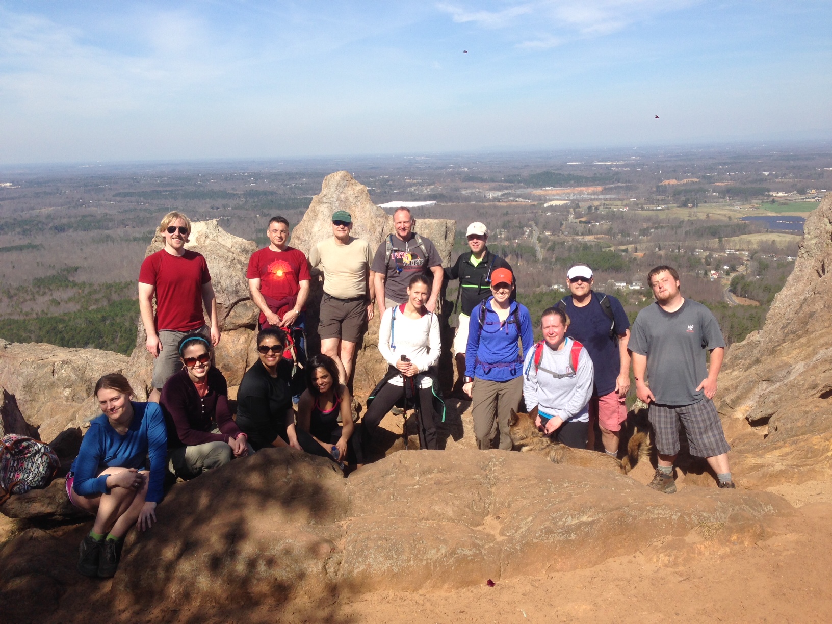
Or, follow in the footsteps of our GetHiking! hike leaders, who take into account the potential spring surge. We aim to start from these and other lesser-known trailheads, to get you out on the trails sooner and with less angst.
In addition to the weekly hikes offered through our seven GetHiking! chapters, we have two special programs designed to avoid spring’s crowds while enjoying its offerings:
The GetHiking! Triangle Spring Series begins March 11. We’ll hike every Sunday afternoon for eight weeks at a different location. For each hike, we offer a short (2-4 miles) and long (5-7 miles) version. The hikes in this series are designed to explore areas where spring wildflowers typically are blooming.
In the GetHiking! Piedmont Explorer series, on the second Saturday of each month, we hike an area that may not be on your radar (but should be!). The hikes are 5 to 8 miles, start at noon, and last about three hours.
Join us as we hike the trails less traveled.
GetHiking! this spring
To find the GetHiking! hike nearest you, click on your local chapter.
That breath of fresh air you inhaled coming out of the house Monday morning — a breath devoid of hot, of wet, of recreational despair — convinced our GetHiking! crews that there’s no need to wait for fall in order to take a fall-like hike. Let’s do it now, our hike leaders declared. Or at least this weekend.
So we will.
This weekend, GetHiking! Charlotte, GetHiking! Triad and GetHiking! Triangle will all exceed the 10-mile mark, a distance typically not contemplated by most until it’s time to toss a fleece into the daypack. Fleece be danged, let’s hike!
Here’s what our three hiking groups have planned for the weekend:
GetHiking! Charlotte, Crowders Mountain State Park. Hike leader Lisa is going the instant replay route with a four-hour hike Saturday at Crowders Mountain State Park, and another four-hour hike Sunday at Crowders. The plan is to depart at 8 a.m. both mornings from the park’s Boulders Access and hike two-hours north on the Ridgeline Trail. At 10 a.m., hikers will about-face and return to the Boulders. Depending upon a hiker’s pace, Lisa estimates they will cover anywhere from 6 to 12 miles. The trail is through rolling terrain. Learn more and sign up here.
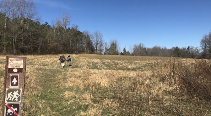
GetHiking! Triad, Doughton Park. Hike leader Jean loves hiking, but she absolutely adores this hike: the 16-mile loop at Doughton Park beginning from the Longbottom Road Access. This Saturday hike begins with a 4.3-mile climb up the Cedar Ridge Trail. The good news? Cedar Ridge constitutes about 80 percent of the climbing on this hike. From there, it’s a memorable 7.5-mile hike on the Bluff Mountain Trail, through vast meadows offering great views, then a 5-mile descent down the Flat Rock Trail. Learn more and sign up here.
60 miles along Falls Lake? This statewide trail does indeed spend 60 of its roughly 1,100 miles hugging the reservoir’s south shore. Our GetHiking! Triangle group will tackle about a sixth of that total: the 10.6 miles from NC 50 west to the Rollingview Recreation Area MST Access. A good kickoff hike for the fall: not too hilly, considerable tree cover, some quality time with the lake. This hike begins at 9 a.m. Learn more and sign up here.
To the glass-half-empty crowd, this weekend’s forecast of rain followed by more rain topped by a dash of drizzle (and more rain) may seem discouraging. But if you don’t mind seeing that half-full glass fill further, the wet weekend offers opportunity. You just need to know how to dress for it and where to best enjoy a walk in the wet woods.
We’ve come up with five of our favorite rainy day romps. We tell you why these trails are better when wet, then refer you to the online hiking guide we compiled for our friends at Great Outdoor Provision Co. for specifics on making each hike happen.
Grab your slicker and embrace the weekend.
1. Sycamore Trail
Umstead State Park, Raleigh
7.2 miles
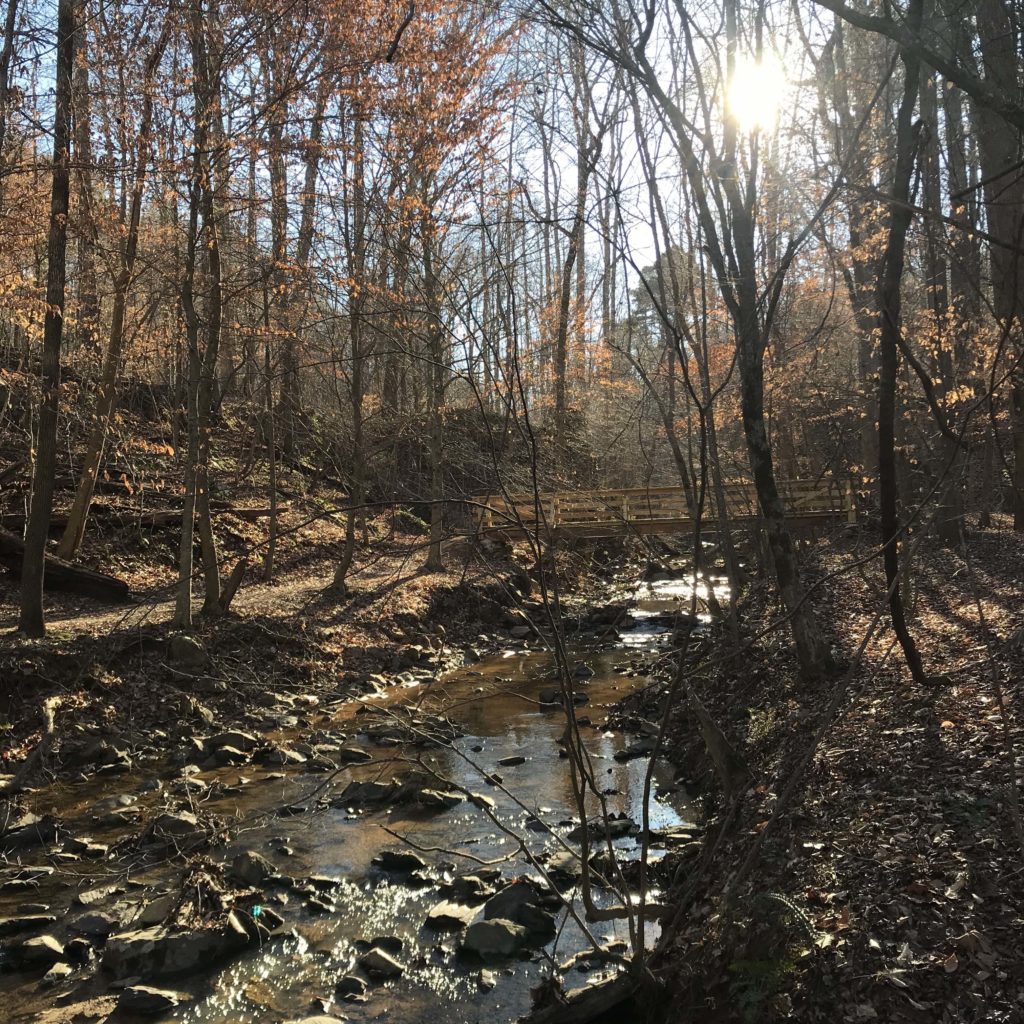
Our favorite hike in the rain, period. In a mild rain, normally nondescript Sycamore Creek turns into a feisty mountain stream. The rock gardens that in drier times collect languid pools convert Sycamore Creek into a whitewater rollick that makes you want to grab the nearest playboat and dive in. Head to the main trailhead off the far parking lot for the entire 7.2 miles, or, get right to the frothy fun by starting from the Bike & Bridle trailhead, for a 4-mile adventure.
More info and directions here.
2. Stone Mountain Loop Trail
Stone Mountain State Park, Roaring Gap
4.5 miles
This popular loop is typically appreciated for its great views — views that will be obscured in this weekend’s forecast conditions. Rather, what you’ll get are low clouds dancing above the meadow that’s home to the Hutchinson Homestead, passage along the especially exuberant Stone Mountain Falls (on a wood staircase) and the occasional peeks across the valley to Wolf Rock when you top out on STMO. Another big plus: you’ll miss the crowds that typically flood the trail this time of year.
More info and directions here.
3. Occoneechee Mountain Loop
Occoneechee Mountain State Natural Area, Hillsborough
3 miles
You like hiking in the mountains in the rain? Then you’ll like hiking at Occoneechee Mountain, where the trail passes through five distinct eco zones, at least two of which transport you to much higher climes. Hiked clockwise, the trail begins with a steep climb (Occoneechee tops out at 867 feet, the highest spot in the Triangle), then deposits you along the Eno. There, a 30-foot cliff provides a cool environment where rhododendron, mountain laurel, galax and other flora of the Southern Appalachians flourish.
More info and directions here.
4. Ridgeline Trail
Crowders Mountain State Park, Kings Mountain (Charlotte area)
12 miles
If you’re properly geared up for the elements, there’s no better opportunity for some through head-clearing than a hike in the rain — a long hike in the rain. The Ridgeline Trail links Crowders Mountain in North Carolina with Kings Mountain State Park in South Carolina. The North Carolina stretch is particularly contemplative, a rolling stretch with no grueling climbs, leaving enough oxygen to fuel the thought process. Not up for a shuttle? Walking in the rain is ideal for an out-and-back hike.
More info and directions here.
5. Price Lake
Blue Ridge Parkway, Milepost 297
2.7 miles
The clouds are never content to settle over Price Lake. Constantly on the move, they shroud the lake in silence one minute, part briefly the next to reveal a glance at Grandfather Mountain. Rhododendron rim the lake, offering a degree of protection from the rain and glowing a brilliant dark green when coated in wet. The trail is accessible (the trailhead is along the parkway) and the distance makes it doable for even occasional hikers.
More info and directions here.
Mel writes: “I am the Hiking Merit Badge coordinator for Troop 395 in Raleigh and we are looking to put together our hiking itinerary over the next 12 months. As you may know, to earn this MB the Boy Scouts have to do five 10+ miles hikes and one 20+ mile hike.”
Mel goes on to mention that he has my “100 Classic Hikes in North Carolina,” but that most of the hikes therein are shorter than 10 miles. Might I, he asks, have some recommendations on longer hikes, and might at least one of them be at the coast, three to four in the Piedmont, and one or two in the mountains?
I love a good, long hike, and do indeed have some thoughts on the subject. Since Mel has already opened the door to shameless plugs of my books, I will go ahead and add that many of the 43 trips in my “Backpacking North Carolina” (UNC Press, 2011) can be done as long hikes. I should also note that my soon-to-be released “Adventure Carolinas: Your Go-To Guide for Multi-Sport Outdoor Recreation,” available from UNC Press in May, does not have specific long hikes but does have a section on “Backcountry Exploration.”
Where were we? Oh, yes. Mel and the Boy Scout long-hike recommendations. I’ll start today with the Coast and Piedmont; I’ll add the mountains next week.
Without further delay, the nominees are:
Coast
There aren’t a lot of long trail options along the coast (unless you count the 301-mile “hike” along the beach from Virginia to South Carolina). But of the two long trails that do exist, both in the Croatan National Forest, both are good ones.
10 miles
Croatan National Forest: Weetock Trail
11 miles
Maysville
The Weetock, located on the south flank of the Croatan National Forest along the White Oak River, was blazed between 2001 and 2003 by the Carteret County Wildlife Club. A significant portion of the trail was rerouted by the USDA Forest Service in 2007; the last time we tried to tackle the Weetock, the Weetock tackled us instead. The first few miles were good: a nice ramble through coastal forest on well-marked, well-maintained trail. But then the trail grew forgetful, frequently losing its place and meandering into the boggy woods or dumping us in a briary thicket. A recent report from Daniel with the coastal Fast Fox Running Co., however, suggests the Weetock has since gathered its thoughts. “The trail is actually in pretty good shape these days!” he reports. Good news, since we liked what we were able to see of the trail back in 2011: boardwalk passages through perpetually wet stretches, great sightlines through a mostly pine forest, creeks that carve surprisingly deep through the woods, and a bluff at one point along the White Oak River.
Trailhead: The easiest place to pick up the trail is from the Haywood Landing Boat Ramp off NC 58. Details here.
Preferred seasons: November to April, to avoid the bugs, slithery types and assorted other pests common in warmer times.
More info: