Winter is a season disliked more in anticipation than in reality.
That dislike begins the first day of summer. Though we generally do spend the summer solstice reveling in the most daylight of the year — 14 hours, 35 minutes and 8 seconds — in the back of our minds we know that it’s all downhill from here. The day after the solstice we’ll be down to 14 hours, 35 minutes and 6 seconds, two seconds that we won’t actually notice, but two seconds that we’re shorted all the same.
Sunlight’s demise continues, a matter of mere seconds a day at first, but by a minute a day come mid-July and two minutes a day by the end of August. Before you know it we’re back to Standard Time and you’re leaving work in the dark.
Meanwhile, something else is happening that puts winter in a new light: perihelion. That’s the point at which Earth’s slightly elliptical orbit brings us closest to the sun. Not appreciably closer, thankfully, or there’d be trouble. But just enough that the sun’s rays are a bit brighter. Coupled with it’s more southerly arc through the sky, an arc that lets sunshine knife sideways through the forest rather than from overhead and you’ve got a winter forest brighter and more vivid than at any other time of the year. Think about it: little if any canopy overhead to block the light, light bypassing what canopy there is by sneaking around the side.
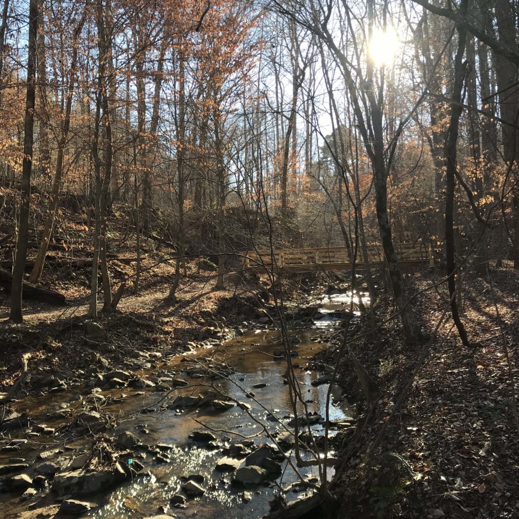
Sunday afternoon we hiked the popular Buckquarter Creek/Holden Mill figure-8 loop at Eno River State Park. About half the hike is along a ridge, the other along the Eno. On the Buckquarter Creek ridge segment I stopped and looked down to the Eno, engorged by two days of rain. It ran fast, it churned, it was alive. A lone canoe made its way cautiously downstream. In summer, the view would have been blocked by green, what chatter there might be from the summer-choked Eno absorbed before it could reach the ridge. The season also let me see across the river to the rise leading up to 690-foot Cox Mountain, the highest point in the park. Climbing the Cox Mountain Trail you get a sense of its nearly 300-foot elevation gain, but seeing it in its entirety you appreciate the rise even more so.
Later, on the longer climb up Holden Mill Trail the trunks of the mature hardwoods cast surprisingly long, surprisingly distinct shadows across the slope rising up from the river. Along the river, the whitecaps off the roiling water managed to sparkle.
Winter isn’t a season enjoyed exclusively along this stretch of the Eno. Other spots where winter is especially good at working its magic:
- Birkhead Mountain Wilderness of the Uwharrie National Forest, Asheboro. More than once I’ve heard the Birkhead area denounced as “not very intersting.” Try it in winter, when long views expose the ancient mountain chain’s still robust slopes. A particular favorite is the Camp 3 Trail, hiking up from North Prong. It’s a gradual mile-long rise through a nearly all hardwood forest nearly devoid of downfall.
- Eno River State Park: Pump Station Trail, Durham. This trail is best-known for the sheltered basin it skims, which hosts one of the best spring wildflower shows in the region. In winter, you fully appreciate that shelter, in the form of a steep, wooded rim rising high on its south side. How high is a mystery: you can’t see the top.
- Pilot Mountain State Park: Mountain Trail, Pinnacle. Circling much of the base of the mountain, the southern and western exposures capitalize from the direct, sideways sun to illuminate a hardwood forest dominated by chestnut oak, which can grow to more than 100 feet in height. Another plus: most visitors stick to the top of the mountain, further enhancing the winter quiet below.
- Crowders Mountain State Park: Ridgeline Trail. Like Pilot Mountain, the two “peaks” here — The Pinnacle and Crowders — attract the bulk of the adoring masses. That leaves lots of quiet time on the 6.2-mile Ridgeline Trail linking the main part of the park with South Carolina. As its name suggests, it’s ridgeline passage allows plenty of downslope views, to the north and south.
- Butner-Falls Lake Game Lands, north of Raleigh. When we can’t get to the coast for our fix of flat hiking through wide-open spaces, we head to this 40,000-acre preserve located largely along the north shore of Falls Lake. A network of limited-access dirt and gravel roads take you past open fields of corn and millet and through bottomland forest dominated by elderly behemoths, all under a vast, usually blue, sky.
Winter is here, the anxious anticipation is over. Get out and savor the season.
More info
To learn more about the places mentioned today, click the appropriate link, where appropriate:
- Eno River State Park
- Pilot Mountain State Park
- Crowders Mountain State Park
- Birkhead Mountain Wilderness. Your best bet for navigating the entire Uwharrie National Forest, including the Birkhead Mountain Wilderness, is with the “Uwharrie Lakes Region Trail Guide,” by Don Childrey (Earthbound Sports). Learn more here.
- Butner-Falls Lake Game Lands. Resources for exploring any game lands in North Carolina are limited; generalized maps showing boundaries and access points can be found on the North Carolina Wildlife Resources Commission web site, here. Because getting around here can be a challenge, we’ve added it to our GetHiking! Winter Wild series of (mostly) off-trail hikes. Our Butner hike is this Saturday (Jan. 11). Learn more and sign up here.