
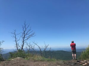
We’ve been thinking about some of our favorite mountain places to explore come fall, and realized that there are a variety of ways we love to explore them. There’s the day hike: spending a day to see as much as possible, then heading home. There’s the basecamp trip: Either establishing camp in a campground or hiking in a short distance in full pack and setting up camp, then doing day hikes from there. Or, there’s the point-to-point backpack trip. Since we all explore differently, we thought, why not look at all three options? So today, we do.
Shining Rock Wilderness
Pisgah National Forest
We love it because: Start high (above 5,000 feet), stay high (topping 6,000 feet) through mostly open terrain.
Miles of trail: 50+
From late spring through mid-fall, it’s not unusual to find the Black Balsam Access over-run with cars, especially on the weekends. Most of those folks won’t get more than a couple miles from their car, meaning once you eclipse this invisible barrier the wide vistas and mountaintop views are yours. If you do the basecamp option and camp at Shining Rock, be sure to catch sunset from atop the rock: it’s about a 10-minute climb from camp, and it can take an extra minute or two to find the easiest route. Also be advised that bear canisters are required for food storage in much of the area.
Best basecamp option: Hike in 4.5 miles in full pack to the base of Shining Rock and set up basecamp. Multiple day-hike options from here, including: 1) Shining Rock Ledge to Cold Mountain (11.4 miles); 2) Art Loeb Trail to Black Balsam and Graveyard Fields (14 miles); 3) Investor Gap Trail to Sam Knob and Little Sam Knob (15.6 miles); 4) Shining Rock down Shining Creek Trail, back up Big East Fork and Greasy Cove trails to the Art Loeb and back (15 miles)
Best day-hike option: Sam Knob/Little Sam Knob loop from Black Balsam Access (8.2 miles)
Best backpacking option: Big East Fork loop, from US 276 trailhead hike up Big East Fork to Shining Rock for Night 1, across the Art Loeb Trail to Yellowstone Prong for Night 2, Yellowstone Prong back to trailhead. 19 miles
More info here.
Standing Indian / Appalachian Trail
Nantahala National Forest
We love it because: A 30-mile loop hike on a linear trail, about two-thirds of which is along ridge
Miles of trail: 50+
The geology of this horseshoe-shaped bowl makes Standing Indian a hiker’s paradise. The Appalachian Trail follows the majority of the rim, for about 18 miles. With at least 7 names trails heading up from the bottom and connecting with the AT, there are numerous loop options (some requiring a short hike on Forest Service road). There’s two notable peaks to summit — 5,499-foot Standing Indian Mountain and 5,250-foot Albert Mountain, with notable views along the ridge. Good camping abounds along the way.
Best basecamp option: Car camp in the Standing Indian Campground. Multiple day-hike options, including: 1. Kimsey Creek to the Appalachian Trail to Standing Indian Mountain returning via the Chestnut Ridge Trail (11 miles); 2. Longbranch Trail to the AT, then south to Albert Mountain and returning down the Hurricane Creek Horse Trail with a short road walk (10 miles); 3. From Mooney Gap, hike south on the AT to Standing Indian Mountain, then down the mountain on Chestnut Ridge Trail to camp (shuttle required; 14 miles).
Best day-hike option: Kimsey Creek Trail to the AT, go north to Standing Indian Mountain, then return via Chestnut Ridge Trail trail (11 miles).
Best backpacking option: 30-mile loop starting from backcountry trailhead and up Longbranch Trail to AT, then south over Albert and Standing Indian mountains, returning via Kimsey Creek Trail.
More info here.
Black Mountains
Mount Mitchell State Park/Pisgah National Forest
We love it because: Topping out just under 6,700 feet, these are the highest mountains east of South Dakota’s Black Hills.
Miles of trail: 30+
Southern Appalachian hardwood forests are great, and in the Black Mountains you’ll hike through plenty. You’ll also hike, starting around 5,500 feet, through spruce and fir forests more commonly found much farther north. That “hiking elsewhere” feel is part of the allure of the Black Mountains. The rugged Black Mountain Crest, which spends much of its time above 6,000 feet, offers great outcrop exploring and great views.
Best basecamp option: Two options. 1. For the full Mount Mitchell experience, camp at the Black Mountain campground and take the Mount Mitchell Trail for 5.5 miles and 3,700 feet of vertical gain to the top of 6,684-foot Mitchell (11 miles roundtrip); or, 2. Camp in the Mount Mitchell State Park campground and spend one day exploring the roughly 8 miles of trail exploring the park, then a second day hiking north on the Black Mountain Crest trail to Mount Craig (1 mile), Big Tom, Balsam Cone, Cattail Peak and Potato Hill before dropping down to Deep Gap after 3.8 miles — a very challenging 3.8 miles.
Best day-hike option: Black Mountain Crest Trail. 6,648-foot Mount Craig is “just” a mile, with four more 6,000-foot peeks before reaching Deep Gap at mile 3.8 (and remember, you’ll need to hike back the same way).
Best backpacking option: Colbert Ridge loop from the book
More info here.
Neusiok Trail (late fall)
Croatan National Forest
We love it because:: Where else can you hike 21 miles through swamp, coastal forest and pine savannah?
Miles of trail: 21
The last place you’d pick to hike — a coastal forest — is the first place we think to go in winter. One, because you can only hike it in late fall and winter (the rest of the year its consumed by flying and slithering things). But mainly because it’s cool, but typically not cold, and exceptionally peaceful, muffled in large part by a dense forest that’s mostly pine on the south end, hardwood on the north.
Best basecamp option: Camp at the Oyster Point Campground and day-hike the various sections of the trail (providing about 3 days of day-hike options).
Best day-hike option: From the Pine Cliff Recreation Area, pick up the Neusiok Trail as it runs along the south bank of the Neuse River before heading inland through rolling coastal forest. After 7 miles, at NC 306, it’s about a 2-mile hike back to the car (briefly on NC 306, then on the gravel road back to Pine Cliff.
Best backpacking option: Meet at the Pine Cliff equestrian lot, then shuttle to the trailhead at Oyster point, staying Night 1 at the Blackjack Lodge Shelter and Night 2 at the Dogwood Shelter. Days of 2, 9 and 10 miles.
More info here.
Mount Rogers / Grayson Highlands
Jefferson National Forest / Grayson Highlands State Park, Virginia
We love it because: High, open terrain with sweeping rock outcrops; reminiscent of exploring out West
Miles of trail: 100+
Anyone who owns a backpack in the Southeast knows Mount Rogers. The National Recreation Area bearing its name covers more than 200,000 acres, with another 4,500 acres in adjoining Grayson Highlands State Park
Best basecamp option: From the Grayson Highlands backcountry lot, hike in full pack 4.5 miles to Rhododendron Gap and set up basecamp. Day hikes include: 1. Lewis Fork Wilderness (various options, starting at around 7 miles); 2. Appalachian Trail to Scales and back via the Crest Trail (12 miles); 3. To Mount Rogers and Whitetop mountains and back (10 miles).
Best day-hike option: From Grayson Highlands to Rhododendron Gap up to Mount Rogers (14 miles).
Best backpacking option: Mount Rogers Loop Trail, starting from Grayson Highlands and including the AT and Crest Trails.