A late spring day, temperature in the mid-50s under a cloudless sky, hiking down Yellowstone Prong east of Graveyard Fields along the Blue Ridge Parkway. It was during that soft-focus, three-day flash that marks the transition from winter to spring, when the natural world is enveloped in pastel greens and yellows and pinks and oranges, the colors, I’ve heard, that the tress will revert to in fall. There was the slightest of breezes, just enough to make the budding trees whisper.
* * *
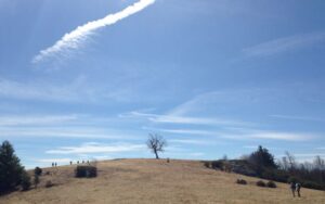
My first hike along the Blue Ridge Parkway, ever, a month or so after moving to North Carolina in early 1992. A moody but not threatening sky hung over the sprawling high meadow of Doughton Park, offering occasional glimpses east to the rolling Piedmont below, west to the impressive Black Mountains, the pinnacle of the East Coast. A temperature of maybe 40, made cooler by a persistent wind sweeping down from the northwest. I took cover behind one of the lonely rock outcrops dotting the open range and watched the scudding clouds alter the scene.
* * *
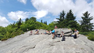
Leading a group along the Tanawha Trail, from Beacon Heights to Price Lake, we stop about midway, atop Rough Ridge, a generous, gently sloping rock face designed seemingly for the purpose of having lunch. It’s warm, bordering on hot but the sun still feels great. I lean back with my head on my pack, forget about lunch and indulge that wonderful warmth, that seeping orange glow of sun penetrating my eyelids. I think we’ve gone far enough, I say to the group. For lunch or for the day is not clear. Still, everyone agrees.
* * *
In 30 years of hiking in the Southeast, these three scenes are among my most memorable. That they all occurred on the mountain section of the Mountains-to-Sea Trail is no surprise. The MST, on its run across the state, spends its westernmost 350 miles linking Clingman’s Dome in the Great Smoky Mountains with the Devil’s Garden Overlook, the point at which the trail tumbles down the Blue Ridge Escarpment to the Piedmont.
It’s a stretch that starts above 6,000 feet (Clingman’s Dome rises to 6,643 feet) and stays above 5,000 feet from Waterrock Knob to the Pisgah Inn, passing through designated wilderness (Middle Prong) and balsam forest. It drops into Asheville before rising up and over the highest point east of South Dakota’s Black Hills, 6,684-foot Mount Mitchell. It skims one of the wildest areas in the East, Linville Gorge, and it runs along the base of the Grandfather Mountain massif. It also has remarkably tranquil stretches of trail where a hemlock forest, a surprise waterfall, a round-the-bend meadow suddenly appear and take your breath away. If you wanted to spend the summer really getting to know the North Carolina mountains, you could easily do so just on the MST. While the MST parallels the Blue Ridge Parkway for much of its mountain run, you rarely know the popular scenic highway is there.
Which is what we plan to do this summer.
This summer, our monthly GetHiking! Weekend Escapes will focus on the Mountains-to-Sea Trail, exploring one 20-mile-or-so stretch of the trail over three days. The sections were selected to showcase the diversity of the Southern Appalachians that can be found on the statewide MST. More than 60 miles of hiking in all.
Each trip in our GetHiking! Weekend Escape on the Mountains-to-Sea Trail series begins with a short sunset hike Friday evening, followed by an all-day hike Saturday and a shorter hike Sunday, which should end around 1 p.m. Below are the three trips, a quick explanation of why we’ve selected them, and the trails we plan do hike. Each trip includes camping, trail snacks and 5 meals (no worries about cooking). Not a camper? Indoor lodging is available near each hike.
Doughton Park
June 10-12
Total distance: 19.6 miles
Basecamp: Doughton Park Campground on the BRP
Why here? The Blue Ridge Escarpment is where the Southern Appalachians dramatically drop to the Piedmont some 2,400 feet below. Nowhere do you get a better sense of that drop than at Doughton Park, especially on the Friday evening hike out to Wildcat Rocks, where you can look, seemingly straight down, to the Caudil Cabin 1,500 below. Most notable on this hike, though, is the passage through open mountain meadows offering views east into the Piedmont, west to the highest of the Southern Appalachians. We pass through a surviving hemlock forest and visit a homestead from pre-parkway days.
The hikes:
- Friday evening: Wildcat Rocks, 3 miles
- Saturday: South Laurel Fork Road back to Doughton Park Campground, 11 miles
- Sunday: Campground to Devil’s Garden Overlook, where the MST leaves the mountains for the piedmont, 5.6 miles
Mount Pisgah/Graveyard Fields
July 22-24
Total distance: 22.8 miles
Basecamp: Mount Pisgah Campground on the BRP
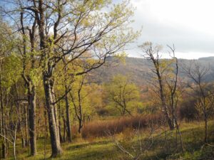
Why here? The hiking is above 5,000 feet, making it a cool respite from the summer heat. But that’s just a part of this section’s allure. We start in the eerily enchanting Graveyard Fields, where intense wildfires a century ago burned so hot that everything eight inches into the topsoil was incinerated. It’s taken years for anything to grow back, and today the area is populated by low-growing foliage. We follow Yellowstone Prong east, past several waterfalls and through mature hardwood forest. Views to the north and south and passage above Pink Beds, a rare mountain swamp.
The hikes:
- Friday evening: Mount Pisgah, 4.5 miles
- Saturday: Graveyard Fields to Mount Pisgah Campground, 13 miles, with a 7-mile option
- Sunday: Mount Pisgah Campground to Big Ridge Overlook, 5.3 miles
Price Lake/Grandfather Mountain/Moses Cone Park
September 9-11
Total distance: 20 miles
Basecamp: Julian Price Campground on the BRP
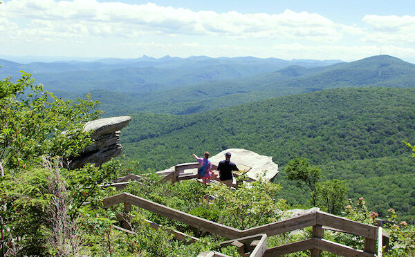
Why here? Saturday’s hike starts by passing under the Linn Cove Viaduct, a highway engineering marvel that took 20 years to get just right. From there, it’s a non-stop run of rugged beauty, from the boulder passages at the base of Grandfather Mountain to the rock outcrop of Rough Ridge to the quiet mature woods that give way to small mountain meadows and finally, a rollicking finish along Boone Fork. There’s a sunset walk Friday around Price Lake, with Grandfather Mountain looming in the distance, and a finish on Sunday on the groomed carriage trails at Moses Cone Park.
The hikes:
- Friday evening: Price Lake Loop, 3 miles
- Saturday: Linn Cove Visitor Center east to Price Park, 10.6 miles
- Sunday: Price Lake to Moses Cone Park (or vice versa)
* * *
Learn more
Find our more about our GetHiking! Weekend Summer Escape series on the Mountains-to-Sea Trail and register to join us by clicking the following links:
Learn more about the statewide Mountains-to-Sea Trail, which runs 1,175 miles from Clingman’s Dome on the Tennessee Line to Jockey’s Ridge at the coast, by visiting the Friends of the Mountains-to-Sea Trail website here.