Summer arrives and our thoughts turn to hiking in the mountains. Until now, the weather, by and large, has been decent for hiking in the piedmont. Come Memorial Day, however, the steamy reality of summer settles in; for many, the prospect of a 90/90 (heat/humidity) day moves hiking to the bottom of their recreational to-do list. Or makes them re-think their options. So we turn to the mountains, which offer two forms of relief.
- Higher elevations, cooler temperatures. In general, for every 1,000 feet of elevation gained, the temperature drops from 3.3 F (when it’s cloudy) to 5.4 F (when it’s not). Thus, if you’re in Raleigh, elevation 384 feet, and plan to hike Mount Mitchell, elevation 6,684 feet, your hike could be as much as 34 degrees cooler.
- Water. Piedmont streams and lakes run tepid in summer, but in the mountains they’re always cool and refreshing.
With that in mind, we give you 7 of our favorite mountain destinations. Note the these aren’t necessary our 7 favorite, but rather, 7 of our favorite. Our ranking changes daily, depending upon our mood.
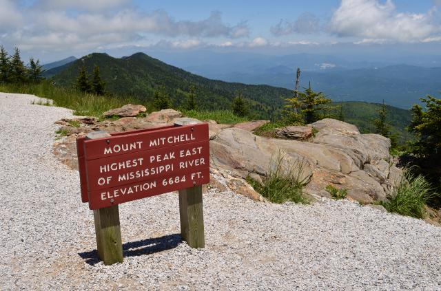
Mount Mitchell Trail
Mount Mitchell State Park, Burnsville
5.5 miles (11 round trip), 3,700 feet of elevation gain, topping out at 6,684 feet
This is both our favorite mountain training hike in North Carolina and a hike we describe to folks as not as hard as it might sound. From the Black Mountain Campground, the hike is certainly challenging throughout, but punishing maybe twice, and both times for less than a half mile. As for bang for your buck, you start in a southern hardwood forest and end in a northern boreal forest where the temperature may be 20 degrees cooler. Also: snack bar at the top.
More info here
Kimsey Creek Trail to Standing Indian Mountain
Nantahala National Forest west of Franklin
11 miles, 2,500 feet of elevation gain
The Standing Indian Campground is a great basecamp for training hikes. The campground sits in a horseshoe-shapped valley rimmed by the ridge-running Appalachian Trail. Numerous trails lead up from the valley, mostly from the Nantahala River, to the AT. Our favorite heads up Kimsey Creek to 5,499-foot Standing Indian Mountain, gaining about 2,500 vertical feet in the process. Return down Lower Trail Ridge for a nice loop hike, at the conclusion of which take advantage of the cooling waters in Kimsey Creek.
More info here
Appalachian Trail: Carvers Gap north to US 19E.
Pisgah and Cherokee National forests
13.7 miles
At first glance, 13.7 miles might seem doable in a day — and it is. Just not for everyone. We were reminded of this recently by a survivor of our last day-hike attempt here, back in 2016. Our last because even some of our sturdiest hikers emerged … angry isn’t quite the right word, but it’s close. On the plus side, this hike starts high — 5,511 feet, at Carvers Gap — and ends low — 2,873 feet at US 19E. Then again, it has at least three good climbs along the way. Test yourself by hiking the Appalachian Trail north 2 miles over Round and Jane balds, to the Grassy Bald split. Feeling strong? Keep moving on the AT through gorgeous ridgeline forest to the Overmountain Victory Shelter. You’re half-way at this point, so why not power through, especially knowing that the views from atop Little Hump and Hump mountains are among the best in the Southeast.
More info here.
Panthertown Valley: Schoolhouse Falls
Nantahala National Forest, Cashiers
30 miles
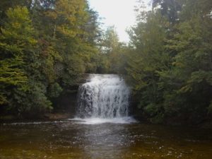
Panthertown is a hiker’s paradise, with more than 30 miles of trail located just outside Cashiers. You’ll find it all here, from pine forests to rock outcrops with views deep into the surrounding country to water, including several accessible waterfalls ending in swimming holes. You have to hike in about a mile-and-a-half for one of the best, Schoolhouse Falls, but what a hike it is, past towering hemlocks and rock outcrops in an area described as the Yosemite of the East. The payoff is sweet: Schoolhouse is a picturesque curtain of water dropping 20 feet into a luxurious pool, at the far side of which is a sand beach. Those of you who apply to the gradual immersion school will be especially pleased by the gentle incline that introduces you to the cold.
More info here
Rock Castle Gorge, Rocky Knob Recreation Area
Blue Ridge Parkway, Floyd, Va.
10.7 miles
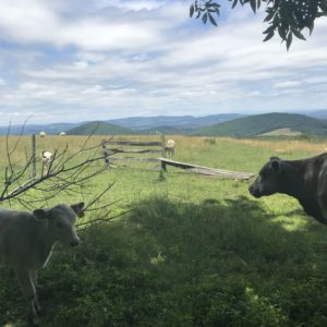
One of our favorite mountain loop hikes, you’ll start this one from the primitive camp parking area with a rigorous climb through mature hardwoods on your way to the vast meadows along the ridge. Share the views with cows before a raucous descent down to Rock Castle Creek. Legs spent? No worries. From here it’s a mellow 4-mile descent along the creek back to your car.. Views; the rugged, intimate beauty of the Blue Ridge Escarpment; Rock Castle Creek near the end; and easy access.
More info here
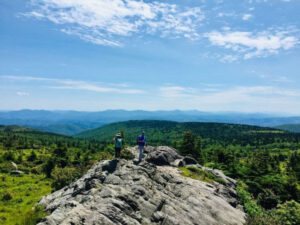
Mount Rogers / Grayson Highlands
Jefferson National Forest / Grayson Highlands State Park, Virginia
100+ miles of trail
More info here and here and here.
Mountains-to-Sea Trail
Blue Ridge Parkway, Pisgah National Forest
350 miles
The MST’s mountain run, from Clingman’s Dome to the Devil’s Garden Overlook, is pretty much one long highlight reel. One of our favorite stretches is also one of its more low-key, running 10.8 miles from South Laurel Fork Road east to the Doughton Park Campground. There are subdued stretches through pristine transitional woods, there are shelf trail stretches that showcase the Blue Ridge Escarpment’s dramatic elevation gain, there are endless views east into the piedmont and, near the end, passage through rolling mountain meadows. Probably our favorite stretch of the MST’s mountain run.
More info here
* * *
Explore with us!
We’re hiking one of these hikes next weekend — and we’d love for you to join us! It’s the MST stretch, and it’s the first of our Summer on the MST Weekend Escape, to Doughton Park, June 10-12. Camping and food are included. Learn more here.
More mountain hikes
Discover more mountain hikes we love in these past blog posts. Click on the link.