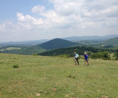
Spring comes, so come the hikers, the seasonal hikers. The, dare we say it, the “fair weather” hikers?
Sure we dare, because they’re probably the first to admit that unless there’s not a cloud in the sky, unless the temperatures not 66 degrees (plus or minus 4 degrees), and unless there’s some pretty flower blooming or some tree putting on a color show, they’ll be doing things indoors, thank you.
But while the weather is perfect and pretty things are popping out of the ground, well, the trails are fair game. At least, the ones the seasonal know about. The ones that are easy to find and, for the most part, easy to hike.
Last week, we told you how to find those trails on your own. This week, we share five of our favorites (one of which we’re hiking this weekend!).
Butner-Falls of Neuse Game Lands
 10+ miles of trail
Bahama
Recommended routes: 4.5 miles, 6 miles
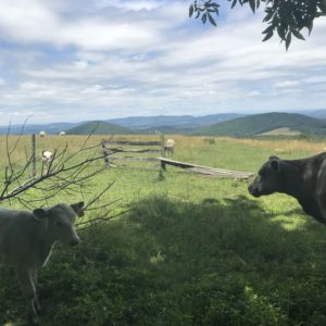
In the Triangle, the two most popular places to hike are Umstead State Park with roughly 5,600 acres, and Eno River State Park with 4,319 acres. What if we were to tell you that there’s a on the north side of Falls Lake more than four times that size with miles of trail? Plus, it’s flat and rarely gets hiked? That should be enough — but we’ll give you a smidge more. The hiking here is open, on gravel access roads that pass meadows and impoundment ponds designed to attract wildlife. Especially good on cool days because of the exposure, especially good on Sundays, since these are gamelands (currently, there is no hunting on Sundays — or from Memorial Day through Labor Day). And again, flat and no crowds. Our guides (see below) highlight a 4.5-mile hike from the Butner Depot and a 6-mile hike from the Flat River Access.
Trailhead: Butner Depot: 4209 Brickhouse Road, Bahama; Flat River Access: Flat River Waterfowl Impoundment, 5094 Old Oxford Road, Durham.
More info here.
Uwharrie National Forest: Birkhead Mountain Wilderness lollipop loop
11.8 miles
Asheboro
Starting from the trailhead off Tot Hill Road, you’ll hike the Birkhead Mountain Trail south for two miles before hitting the popular loop that Boy Scouts, among others, have been using for years to cut their backpacking teeth. Where the Robbins Branch Trail enters from the right, continue straight on the Birkhead for two miles. Note along the way that despite the fact this is a designated wilderness, the trail is well blazed. After two miles, go right on the Hannahs Creek Trail, where, for the first time, you abandon ridgelines in favor of passages along holly-clogged creeks. After a mile and a half, go right on the Robbins Branch Trail, which climbs a rocky (for the Piedmont) ridgeline before dropping to its namesake creek and rejoining the Birkhead after 3.2 miles. Go left for the two-mile return to your car. You can filter water from Hannahs Creek and Robbins Branch, though both run low in summer and during dry weather.
Trailhead: 3091 Tot Hill Farm Road, Asheboro.
More info here.
Pilot Creek Trail
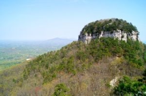
Pilot Mountain State Park
6.6 miles (out and back)
When we first began recommending uncrowded trails more than a dozen years ago, we recommended the trails accessed at the summit of Pilot Mountain. But since 2012, those trails have been discovered: on nice weekends it can take a half hour or more just to score a parking spot up top. Now, our favorite Pilot Mountain trail is Pilot Creek, which starts from an access off Boyd Nelson Road north of the park and works its way along the north flank of the mountain to connect with the Grindstone Trail. Pilot Creek offers much of what hikers flock to Pilot Mountain for: rocky terrain and some moderately challenging climbs. You won’t get the views (it sticks to the base of the mountain), but you won’t get the crowds, either.
Trailhead: Pilot Creek Access, Pilot Mountain State Park, 382 Boyd Nelson Road, Pinnacle
More info here.
Rock Castle Gorge Loop
Rocky Knob Recreation Area, Blue Ridge Parkway (Virginia)
10.4 miles
This is one gorgeous hike that the masses aren’t likely to undertake. And they certainly aren’t going to pick it up from its hidden trailhead at the bottom of the gorge. Pick up the trail and hike counterclockwise, hiking up Little Rock Castle Creek through a spectacular hardwood forest. Mellow at first, the trail has a steep climb requiring some scrambling, before entering another mature hardwood forest and, shortly, reaching the Parkway. From there, it’s about 3.5 miles along the ridge, through several open meadows, before descending back into the gorge. The last 2.5 miles is a relaxing downhill along Rock Castle Creek.
Trailhead: Primitive camping trailhead at the base of the gorge, off VA 8. From the Blue Ridge Parkway near the Rocky Knob Campground, take VA 8 headed south. After 3.6 miles, go right on Rock Castle Road, which will terminate shortly at the trailhead. Hike in about 200 feet to pick up the trail.
More info here.
Bluff, Stream, Dam Site and Discovery trails melange
Medoc Mountain State Park, Hollister
6 miles
Medoc Mountain is on the cusp of the coastal plain, but its demeanor is decidedly Piedmont. Low hills are divided by the clear Little Fishing Creek, which carves a steep bluff on the south side of the park. We’ll hike atop that bluff, through splashes of holly and mountain laurel and past the site of the first winery in the U.S. (the park gets its name from a province in the Bordeaux region of France known for its vineyards). Perhaps best of all, because of its off-the-beaten-path location it is one of the least-visited state parks in North Carolina.
Trailhead: The Visitor Center is at 1541 Medoc State Park Road, Hollister, NC. The trailhead for the described is 1.3 miles to the south, off Picnic Area Road.
More info here.
* * *
GetHiking! Guides
 We have guides from our GetHiking!- and GetBackpacking!-run trips for four of the hikes described. Check ‘em out by clicking on the appropriate link: